- Muine Bheag halt
-
Muine Bheag 
Bagenalstown 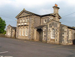
Muine Bheag halt
Photo: Liam Murphy [1]Location Place Muine Bheag Local authority County Carlow Coordinates 52°41′57″N 6°57′09″W / 52.699098°N 6.952521°WCoordinates: 52°41′57″N 6°57′09″W / 52.699098°N 6.952521°W Operations Station code 47 Platforms in use 2 History 24 July 1848 Station opens as Bagnalstown By April 1910 Station renamed Bagenalstown 30 March 1963 Station closed 1988 Station reopened and renamed Muine Bheag Iarnród Éireann - Ireland railway stations A B C D E F G H I J K L M N O P Q R S T U V W X Y Z Muine Bheag halt serves the town of Muine Bheag in County Carlow The station opened on 24 July 1848 as Bagenalstown. It was closed for goods traffic on 6 September 1976,[1] but re-opened, re-named, in 1988. The station is staffed; the main platform is fully accessible but the far-side platform (used only when two trains pass in the station) is accessible only by stairs and a footbridge.
History
Opened by the Great Southern and Western Railway, the station was amalgamated into the Great Southern Railways. The line was then nationalised, passing to the Coras Iompair Éireann with the Transport Act 1944 which took effect from 1 January 1945.
Although the station closed the line remained open and passed on to the Iarnród Éireann in 1986.
Preceding station Iarnród ÉireannFollowing station Carlow Intercity
Dublin-WaterfordKilkenny
MacDonaghHistorical railways Milford Great Southern and Western Railway
Dublin-WaterfordGowran References
- ^ "Bagenalstown station". Railscot - Irish Railways. http://www.railscot.co.uk/Ireland/Irish_railways.pdf. Retrieved 2007-08-30.
- Butt, R. V. J. (1995). The Directory of Railway Stations: details every public and private passenger station, halt, platform and stopping place, past and present (1st ed.). Sparkford: Patrick Stephens Ltd. ISBN 1-8526-0508-1. OCLC 60251199.
- Jowett, Alan (2000). Jowett's Nationalised Railway Atlas (1st ed.). Penryn, Cornwall: Atlantic Transport Publishers. ISBN 0-9068-9999-0. OCLC 228266687.
- Jowett, Alan (March 1989). Jowett's Railway Atlas of Great Britain and Ireland: From Pre-Grouping to the Present Day (1st ed.). Sparkford: Patrick Stephens Ltd. ISBN 1-8526-0086-1. OCLC 22311137.
Categories:- Iarnród Éireann stations in County Carlow
- Railway stations in County Carlow
- Railway stations opened in 1848

Wikimedia Foundation. 2010.