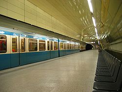
- München Karlsplatz station
-

Karlsplatz Operations Category 4 Type Hp Platforms in use 2 DS100 code MKP Construction and location Location Munich State Bavaria Country Germany List of railway stations in Bavaria  Karlsplatz (Stachus)
Location Place Altstadt Borough Altstadt-Lehel Operations Serviced by U4, U5 Platforms in use 2 München Karlsplatz (Stachus) is an underground S-Bahn and U-Bahn station below the Karlsplatz in central Munich. It is one of the busiest stations in Munich, as it is located at the western end of Munich's Altstadt (Old Town).
Karlsplatz is also a stop on the Munich tramway, located on the Altstadtring, the Old Town's periphery road. This stop is served by routes
 ,
,  ,
,  ,
,  ,
,  and
and  .[1]
.[1]The underground facilities were built as part of the S-Bahn tunnel through central Munich in the early 1970s.
Contents
Levels
The station is divided into five levels.
Level 1
The first level, just below road level, is home to a large shopping mall which is due for renovation in the next years. Large shops have branches here, for instance Kaufhof or Woolworths.
Level 2
Level two has a branch of the Stadtsparkasse, a large local bank, as well as ticket counters and eateries.
Level 3
The third level holds the S-Bahn station with two tracks and three platforms, arranged in the Spanish solution: The island platform is for boarding only and the side platforms are for disembarking. The lines S1, S2, S4, S5, S6, S7 and S8 call at this station.
Level 4
The fourth level allows interchange between the S-Bahn and U-Bahn.
Level 5
The fifth level holds the U-Bahn station with two tracks and two platforms. Lines U5 and U4 call here, travelling in north-west direction. The station is the deepest in the whole network and also has the longest escalator.
Preceding station Munich S-Bahn Following station toward Wolfratshausen, Tutzing, Herrsching,
Geltendorf, Mammendorf,
Petershausen, Freising or AirportStammstrecke Preceding station U-Bahn Following station toward WestendstraßeU4 toward Arabellaparktoward Laimer PlatzU5 toward Neuperlach SüdReferences
- ^ "Munich tram network". MVG. http://www.mvg-mobil.de/netzplaene/images/tramnetz.pdf. Retrieved 20 June 2011.
Coordinates: 48°08′21″N 11°33′57″E / 48.13917°N 11.56583°E

This Munich S-Bahn-related article is a stub. You can help Wikipedia by expanding it.
