Huntingdon Road

Huntingdon Road
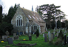
The chapel of the Ascension Parish Burial Ground, off Huntingdon Road.

Huntingdon Road is a major arterial road linking central Cambridge, England with Junction 14 of the M11 motorway and the A14 northwest from the city centre.[1][2] The road is designated the A1307.

At the southeastern end, the road links with Histon Road (B1049), Victoria Road (A1134) and Mount Pleasant. [3] It continues as Castle Street, then Magdalene Street over the River Cam and Bridge Street, into the centre of the city.

The University of Cambridge colleges Fitzwilliam College (front entrance on Storey's Way, south off Huntingdon Road), Girton College, and Murray Edwards College (formerly New Hall), are located off the road. Girton College is some distance from central Cambridge as a former women's college, just south of the village of Girton.

Also on the road are:

Gallery

See also

References

Coordinates: 52°13′38″N 0°05′03″E / 52.22719°N 0.08407°E / 52.22719; 0.08407


Wikimedia Foundation. 2010.

Игры ⚽ Поможем написать курсовую

Look at other dictionaries:

  • Road protest (UK) — Road protest in the United Kingdom usually occurs as a reaction to a stated intention by the empowered authorities to build a new road, or to modify an existing road. Protests may also be made by those wishing to see new roads built or… …   Wikipedia

  • Huntingdon Valley (SEPTA station) — Huntingdon Valley is an abandoned train station located on Terwood Road near Old Welsh Road (PA 63) in Lower Moreland, Pennsylvania, not far from the Pennypack Creek. The station was a stop on the Reading Railroad s Newtown Line. It later became… …   Wikipedia

  • Huntingdon, British Columbia — Huntingdon is a community within Abbotsford, British Columbia, Canada. It is located immediately north of the Canada US Border. The main road through the community is Highway 11. The name of the community is also the present name of the border… …   Wikipedia

  • Huntingdon, Pennsylvania — Infobox Settlement official name = Pagename other name = native name = nickname = Standing Stone settlement type = Borough motto = imagesize = image caption = flag size = image seal size = image shield = shield size = image blank emblem = blank… …   Wikipedia

  • Huntingdon Valley, Pennsylvania — Geobox City name = Huntingdon Valley native name = other name = other name1 = category = image size = image caption = St| flag size = symbol = symbol size = nickname = motto = country = United States state = Pennsylvania region = Montgomery… …   Wikipedia

  • Huntingdon railway station — Infobox UK station name = Huntingdon code = HUN manager = First Capital Connect locale = Huntingdon borough = Huntingdonshire usage0405 = 1.360 usage0506 = 1.373 usage0607 = 1.448 platforms = 2 start = Huntingdon railway station serves the town… …   Wikipedia

  • National Register of Historic Places listings in Huntingdon County, Pennsylvania — Location of Huntingdon County in Pennsylvania This is a list of the National Register of Historic Places listings in Huntingdon County, Pennsylvania. This is intended to be a complete list of the properties and districts on the National Register… …   Wikipedia

  • A14 road (England) — UK road routebox road= A14 length mi= 127 length km= 204 direction= East / West start= Catthorpe destinations= Rugby Market Harborough Northampton Wellingborough Kettering Corby Huntingdon Peterborough Cambridge Ely Newmarket Bury St Edmunds… …   Wikipedia

  • Old North Road railway station — Old North Road Old North Road station in March 2009 Location Place Longsto …   Wikipedia

  • Selina Hastings, Countess of Huntingdon — Selina, Countess of Huntingdon Selina, Countess of Huntingdon (24 August 1707 – 17 June 1791) was an English religious leader who played a prominent part in the religious revival of the 18th century and the Methodist movement in England and Wales …   Wikipedia

Share the article and excerpts

Direct link
Do a right-click on the link above
and select “Copy Link”