- Morrocoy National Park
-
Morrocoy National Park 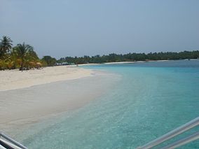
Cayo SombreroLocation of Morrocoy National Park
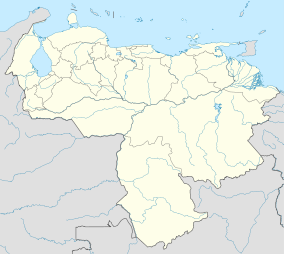
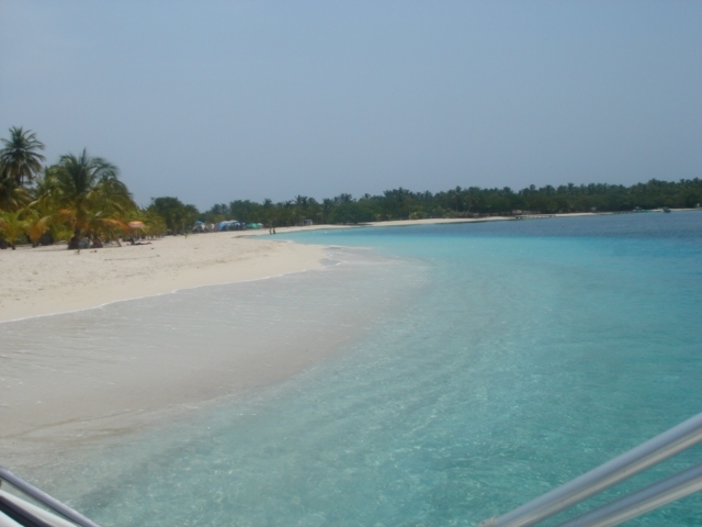
Nearest city Tucacas and Chichiriviche Coordinates 10°47.812′N 68°19.107′W / 10.796867°N 68.31845°WCoordinates: 10°47.812′N 68°19.107′W / 10.796867°N 68.31845°W Area 320.9 km² Established 26 May 1974 Governing body INPARQUES Morrocoy National Park is located in the northwest of Venezuela, between the towns of Tucacas and Chichiriviche, at the south east part of Falcón. Its continental and sea areas include mountains, shoreline, mangrove swamps, coral reefs and little islands called “Cayos”. It has a surface area of 32,090 hectares. It was declared national park by the Venezuelan government on 26 May 1974 in order to protect it from human intervention. Flora and Fauna are considered to be very important by local administration. It is a nature reserve and a tourist attraction. People go there mostly on weekends and holidays to have beach days, see the landscape, do some water sports, etc. People can take their private boats or pay for a boat service to stroll around and get to the "cayos". [1]
Contents
Visiting Morrocoy National Park
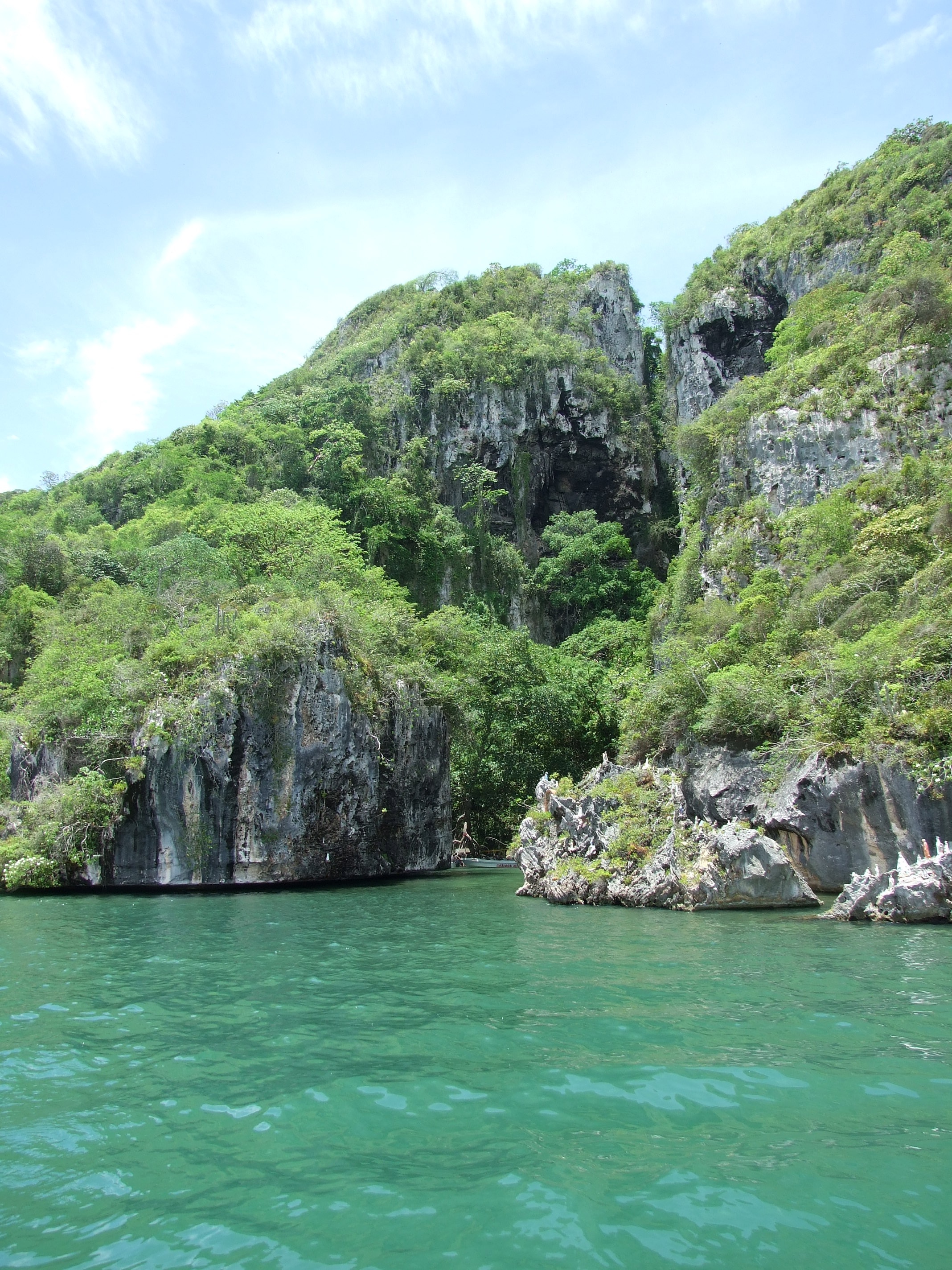
 Cueva de la Santísima Virgen (Cave of the Virgin Mary).
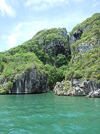
Visitors of the Morrocoy National Park have different places to go and activities to do. In the continental area there is the mountain "Cerro Chichiriviche". On the shoreline there are mangrove swamps and lakes. In the sea area, there are the little islands with white sand called "cayos". The main cayos are: Borracho, Punta Gorda, Sal, Los Muertos, Peraza, Pelón, Sombrero, Pescadores, Playuela y Playuelita, Boca Seca, Animas, Suanchez y Punta Brava. Among the activities that can be done is these areas are: beach activities, boat rides, fishing (with permission), scuba diving, swimming, picnic, sailing, etc. There is as well an island called " Isla de Aves", where research and studies related to ornithology can take place, and a cave called "Cueva del Indio" with petroglyphs. To arrive to Morrocoy National Park by car from Caracas, people can take the expressway Caracas - Morón, then go by the "Troncal 3" way in direction to the towns "Tucacas" and "Chichiriviche" and the city of Coro. [2]
Flora and Fauna
The continental area corresponds to dry tropical forest climate. There are as well plants adapted to high salinity and in some areas xerophilous vegetation like cactus. Some examples of plants that can be found are: "Olivo Caparis", "Indio desnudo" (Bursera simaruba) "Saladillo", different types of mangrove swamps (Rhizophora, Avicennia germinans, Laguncularia racemosa and Conocarpus erectus) etc.The sea vegetation includes seaweeds of various types (Fanerógama marina, Thalassia testudinum,Justicia falconensis, Aspilia falconensis, Phthirusa marítima, Lorantaceae, Pitcairnia steyermarki) some only found in this park. The fauna of the park include approximately 266 spices of birds. Among the list of birds are: "corocoras", "tijeretas de mar", flamings, pelicans, herons and much others. As well as the birds, the park has turtles, dolphins, whales, coral reefs and fish like: "mero", "pargo", "curbina", "sábalo" and sea bass. In the continental area there are mammals like: deers, "araguatos" (a type of monkey) "cunaguaros"(a type of wild cat)and others.[2] [1]
References
- ^ a b "PARQUE NACIONAL MORROCOY [Morrocoy National Park]" (in Spanish). Venezuela: INPARQUES. http://www.inparques.gob.ve/index.php?parques=view&codigo=pn_0017&sec=1. Retrieved 2010 September 20.
- ^ a b "PARQUE NACIONAL MORROCOY [Morrocoy National Park]" (in Spanish). Venezuela: Venezuelan government. http://www.gobiernoenlinea.ve/venezuela/perfil_turismo_parques5.html. Retrieved 2010 September 22.
External links
National parks of Venezuela Western Venezuela Cerro Saroche · Ciénagas de Juan Manuel · Cueva de la Quebrada del Toro · Dinira · El Guache · Morrocoy · Médanos de Coro · Perijá · Sierra de San Luis · Terepaima · Tirgua General Manuel Manrique · Yacambú · Yurubí
Venezuelan Andes Chorro El Indio · El Tamá · General Cruz Carrillo en Guaramacal · General Juan Pablo Peñalosa en los Páramos El Batallón y La Negra · Sierra La Culata · Sierra Nevada · Tapo-CaparoLos Llanos Aguaro-Guariquito · Santos Luzardo · Río Viejo San CamilloCentral Region Eastern Region Region of Guayana Canaima · Duida-Marahuaca · Jaua-Sarisariñama · Parima Tapirapecó · Serranía de la Neblina · YapacanaOffshore Archipiélago Los Roques · Cerro El Copey · Laguna de la RestingaCategories:- IUCN Category II
- National parks of Venezuela
- Falcón
- Protected areas established in 1974

Wikimedia Foundation. 2010.