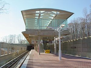
- Morgan Boulevard (WMATA station)
-
Morgan Boulevard 
Station statistics Address 300 Garrett Morgan Boulevard
Landover, MD 20785Lines Connections TheBus Structure Open-cut Platforms 1 island platform Tracks 2 Parking 635 spaces Bicycle facilities 9 racks, 40 lockers Other information Opened December 18, 2004 Accessible 
Code G04 Owned by Washington Metropolitan Area Transit Authority Formerly Summerfield (while under construction) Services Preceding station Washington Metro Following station Addison Roadtoward Franconia–SpringfieldBlue Line Largo Town CenterTerminusMorgan Boulevard is an island platformed Washington Metro station in Prince George's County, Maryland, United States. The station was opened on December 18, 2004, and is operated by the Washington Metropolitan Area Transit Authority (WMATA). Providing service for the Blue Line, the station is located on Garrett Morgan Boulevard, less than a mile from FedEx Field, the home of the Washington Redskins. It is about a 15-minute walk to the stadium from the station. This is one of the few stations not served by Metrobus. The Prince George's County bus system, called simply TheBus, serves this station. The platform at this station is wider than others and the station features double the number of faregates of similar stations because of the large volumes of passengers using it before and after football games.[1] For commuters, there is a day care facility at the station.
As of 2009, the Morgan Boulevard station has the lowest average weekday ridership of the entire system.[2]
History
In October 1996, the proposed routing for the extension of the Blue Line to Largo received a favorable environmental impact statement thus allowing for the project to move forward.[3] The plan represented the first expansion to the original 103-mile (166 km) Metro network and would include both the then named Summerfield and Largo stations.[3] The station gained approval from Congress as part of the extension in February 2000 with the federal government contributing $259 million towards its construction.[4]
Construction began in 2001, and by 2002 its name was changed to Morgan Boulevard as a result of the Prince George's County Board changing the name of the street from Summerfield Boulevard to Morgan Boulevard in memory of Garrett Morgan, the African-American inventor of the stop-go traffic light.[5] The station opened on December 18, 2004.[6] Its opening coincided with the completion of 3.2 miles (5.1 km)[7] of rail east of the Addison Road station and the opening of the Largo Town Center station.[6] The final cost of building it, its sister station and rail extension was $456 million.[1]
References
- ^ a b Partlow, Joshua (January 1, 2005). "Newest stations to ease game-day crush; Redskins fans await rail, trail to FedEx". The Washington Post: p. B3.
- ^ "Metro Average Weekday Passenger Boardings" (PDF). Washington Metropolitan Area Transit Authority. 2009. http://www.wmata.com/pdfs/planning/2009%20Metrorail%20boarding%20by%20station.pdf. Retrieved July 28, 2010.
- ^ a b Fehr, Stephen C. (October 18, 1996). "Plan to extend P.G. Metro line moves forward; Environmental study allows Largo stops". The Washington Post: p. C3.
- ^ Layton, Lyndsey (February 4, 2000). "Federal funds promised for new Metrorail stops". The Washington Post: p. A1.
- ^ Meyer, Eugene L. (August 17, 2002). "Base living with cheers, a few fears". The Washington Post: p. J1.
- ^ a b Dana, Rebecca (December 19, 2004). "Metro, Prince George's extend their reach; Two new Blue Line stations open, bringing passengers and economic potential". The Washington Post: p. C2.
- ^ Washington Metropolitan Area Transit Authority (July 2009). "Sequence of Metrorail openings". http://www.wmata.com/about_metro/docs/metrofacts.pdf. Retrieved July 28, 2010.
External links
 Media related to Morgan Boulevard (Washington Metro) at Wikimedia Commons
- WMATA: Morgan Boulevard Station
- StationMasters Online: Morgan Boulevard Station
- The Schumin Web Transit Center: Morgan Boulevard Station
- Station from Google Maps Street View
Coordinates: 38°53′36.9″N 76°52′6.5″W / 38.893583°N 76.868472°W
Categories:- Blue Line (Washington Metro)
- Washington Metro stations in Maryland
- Railway stations opened in 2004
Wikimedia Foundation. 2010.
