- Serra de Paüls
-
Serra de Paüls 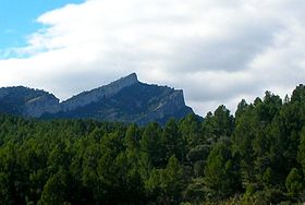
Montsagre de PaülsElevation 1,091 m (3,579 ft) Location Location Terra Alta and Baix Ebre,
 Catalonia
Range Ports de Tortosa-Beseit Coordinates 40°56′52.8″N 00°23′15.5″E / 40.948°N 0.387639°ECoordinates: 40°56′52.8″N 00°23′15.5″E / 40.948°N 0.387639°E Geology Type Limestone Climbing Easiest route Drive from Paüls or Prat de Comte Serra de Paüls is a mountain range in the northern side of the Ports de Tortosa-Beseit, Catalonia, Spain. The highest summit, Punta de l'Aigua has an altitude of 1,091.6 metres above sea level.[1] The central part of the range is known as Montsagre de Paüls.
This range is named after the town of Paüls, located on its SE side. Together with neighboring and parallel Serra de l'Espina the Serra de Paüls is within the geological area that connects the Ports de Tortosa-Beseit mountain massif with the Catalan Pre-Coastal Range.[2]
See also
- Ports de Tortosa-Beseit
- Mountains of Catalonia
- Iberian System
References
- ^ "Mapa Topogràfic de Catalunya". Institut Cartogràfic de Catalunya. http://www.icc.cat/vissir2/. Retrieved 9 - IX - 2010..
- ^ Ports de Beseit
External links
Categories:- Catalonia geography stubs
- Ports de Tortosa-Beseit
- Mountains of Catalonia
- Terra Alta
- Baix Ebre

Wikimedia Foundation. 2010.