- Moneenroe
-
Moneenroe
An Móinín Rua— Town — Location in Ireland
 Moneenroe
Coordinates: 52°49′47″N 7°09′42″W / 52.8297°N 7.16165°WCoordinates: 52°49′47″N 7°09′42″W / 52.8297°N 7.16165°W Country Ireland Province Leinster County County Kilkenny Government - Dáil Éireann Carlow–Kilkenny - EU Parliament East constituency Time zone WET (UTC+0) - Summer (DST) IST (WEST) (UTC-1) Area code(s) +353 Irish Grid Reference Website kilkennycity.ie Moneenroe (from Irish: An Móinín Rua, meaning "the little red bog") is a townland, electoral division and village in north County Kilkenny, Ireland. It is located in the province of Leinster along the N78 road about 21 kilometres (13 mi) from Kilkenny city in the south-east of the island of Ireland. Moneenroe is a census town with a population of about 688.
Moneenroe is approximately 5 kilometres (3.1 mi) from Castlecomer and 16 kilometres (9.9 mi) from Carlow town. Clogh village is 2 kilometres (1.2 mi) west.
Contents
History
In the past many from Moneenroe worked at the coal mines at Deerpark Mines which closed in the 1960s.
Geography
It is located on the N78 main road between Castlecomer and Carlow town, approximately 5 kilometres from Castlecomer and 16 kilometres from Carlow town. The village borders with County Laois at several points, with Crettyard being the closest townland in County Laois.
Townlands in the electoral division of Moneenroe include Coolbawn, Croghtenclogh, Gorteen, Moneenroe, Smithstown and Uskerty.[1][2]
Móinín Rua means "The little red bog" due to the marshy land in some parts of the townland.
Moneenroe is the most densely populated rural area in the county.[3]
Demographics
As of the 2006 census, by the Central Statistics Office, Moneenroe’s population was 688.[4] This was a 1.5% increase since 2002.[4] There is exactly a 50%/50% split of males and females in the village.[4]
Landmarks
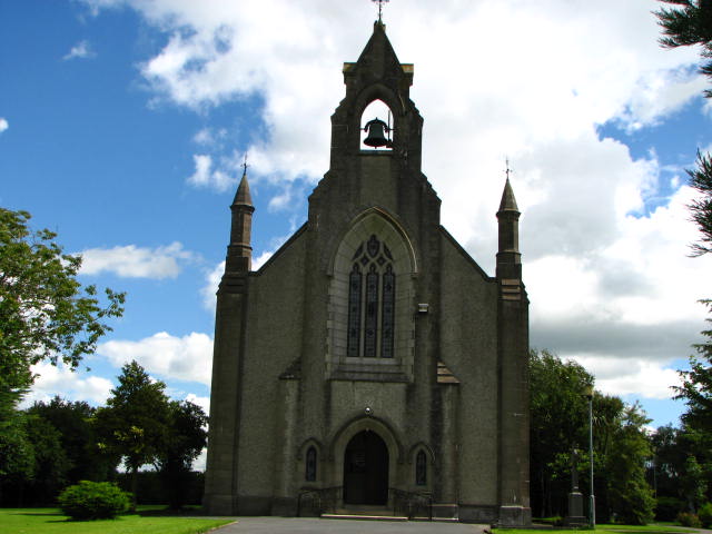
 Church of the Sacred Heart
There are two local churches and a community hall. The Catholic Church is called Moneenroe Church of the Sacred Heart and the foundation stone was blessed in 1928 and was dedicated September 14, 1930. The most striking feature inside this Church is the windows.[5] There is also a Church of Ireland church. The hall is called Moneenroe Parish Hall.[6]
Education
Moneenroe National School is a co-educational school with a catholic ethos.[7] The school participates in the National Children’s Choir.[8]
Goverence
The local government is Kilkenny County Council. Ballyragget and its rural area forms an Electoral District which includes Attanagh, Ballyragget, Castlecomer, Clogh, Coon, Moneenroe, Ardra and Muckalee. The County Council representatives from the Ballyragget electoral district are Maurice Shortall, Mary Hilda Cavanagh, Pay Millea, Dan Brennan and Catherine Connery.
In European Parliament elections Moneenroe is part of the Ireland East constituency for voting purposes. The elected representatives in the 2009 elections for the East were Liam Aylward, Nessa Childers and Mairead McGuinness.
is currently part of the Carlow–Kilkenny constituency which is a parliamentary constituency represented in Dáil Éireann, the lower house of the Irish parliament or Oireachtas. The TDs serving the area are currently John J. McGuinness, Phil Hogan, Bobby Aylward, M. J. Nolan and Mary White.
Industry
Agriculture employs about 100 people. The Castlecomer district has 60 farms. These range between 10 and 100 hectares with a total of 2003 hectares being farmed. There are 4451 cattle and 768 sheep, and farming is done with grassland machines, tillage machines, tractors, winter feeding and milking equipments. Specialist farms include beef production, dairy and mixed grazing livestock.
After the closure of the coal mines in the 1960s, there was mass emigration to the USA, Canada, the UK and Australia as people searched for work and a better life than that on the dole. Over the years there have been many factories which have closed in the locality leaving people to search for work in places such as Kilkenny, Carlow, Portlaoise and Dublin.
In the 1970s the building of the Avonmore plant in Ballyragget helped keep local young people in the area gain local employment and this continued with the jobs created when the plant was operational. The caravan manufacturing factory was briefly a large employer in the area. To the disappointment of locals this was closed down.
Castlecomer mills was also a major employer of clothing such as Lycra. However, this closed to a much cost-effective market in the Far East and has left a void for direct employment in the area since. Due to a lack of local support from Dáil members for industry in the area over the last ten years, there is a serious migration issue to Dublin and beyond.
However, further investment in the area came quickly when Roadstone (now called Ormonde brick) constructed a factory in Ardra for the manufacture of bricks for the building industry. However, this factory is as good as closed now because of high costs, the slowdown in the building industry and also fears about safety of employees and the local environment.
Sport
Railyard Gaelic football team or Railyard GFC was founded mainly by members of Moneenroe FCA in 1943.[9] The Railyard colours of red and white are steeped in glory for years. The Railyard GAA team was a great source of enjoyment to the mining community when the majority of local men worked there in the early to mid 1900’s. Senior club Gaelic football championships were the norm and this encouraged children to gain a great appetite for the sport. The club were Senior football league winners as recently as 2009 as a new crop of talent filters through.
Old Road Villa soccer club – currently no team entered in Carlow soccer league Junior divisions. A ladies team was entered in the Kilkenny and District league, which performed well on the maiden voyage in the cup competition.
Castlecomer Camogie Club comprises players from all of the local primary schools in the area including Clogh, Moneenroe, Castlecomer and Firoda.[10]
Transport
Moneenroe is situated on the Dublin to Clonmel Bus Eireann bus route. Also, a private bus service Buggy’s of Castlecomer has a daily bus service to and from Carlow town. Ring a Link is a community based rural transport which operates a route in the Northeast of the county covering Castlecomer, Ballyraggett, Coan, Conahy, Muckalee, Ballyouskill, Clogh and Moneenroe.[11]
Culture
It is known as the Unofficial Capital of North Kilkenny.[citation needed] Moneenroe was home to Nicholas Boran, a professed communist and union organizer in the Castlecomer mines.[12]
References
- ^ Moneenroe DEDs, Census of Ireland 1911
- ^ Derelict Sites (Urban Areas) Regulations, 2009
- ^ FOOTPATH CONTINUES, Kilkenny People
- ^ a b c Census 2006 Table 5, Central Statistics Office
- ^ Moneenroe Church of the Sacred Heart photo from geograph.ie
- ^ Moneenroe Parish Hall
- ^ Moneenroe National School on site clogh.com.
- ^ Making learning fun at Moneenroe NS, Kilkenny People and News from nationalchildrenschoir.org
- ^ Railyard from kilkennycats.com
- ^ Comer Camogie, Kilkenny People
- ^ National Development Plan Advertising Kilkenny People, Friday, October 15, 2004
- ^ Closing the Mine in Castlecomer, Walter F. Kuentzel, University of Vermont
External links
Categories:- Towns and villages in County Kilkenny
- Census towns in County Kilkenny
- Articles on towns and villages in Ireland possibly missing Irish place names

Wikimedia Foundation. 2010.