- Mona Vale, Christchurch
-
Mona Vale 
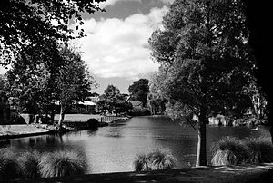
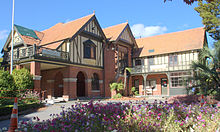
The Avon River at Mona ValeType Public park Location Christchurch Coordinates 43°31′23.89″S 172°36′30.67″E / 43.5233028°S 172.6085194°ECoordinates: 43°31′23.89″S 172°36′30.67″E / 43.5233028°S 172.6085194°E Area 4 ha Created 1899 Operated by Christchurch City Council Status Open all year Official name: Mona Vale Designated: 7-Apr-1983 Reference #: 283 Official name: Mona Vale Gatehouse Designated: 7-Apr-1983 Reference #: 1799 Mona Vale, with its homestead formerly known as Karewa, is a public park of 4 ha in the Christchurch suburb of Fendalton. The homestead and gate house are both listed as heritage buildings with the New Zealand Historic Places Trust (NZHPT). The fernery and the rose garden, together with the setting of the park along the Avon River, add to the attractiveness of the property. It is one of the major tourist attractions of Christchurch.
Contents
Geography
The western boundary of Mona Vale is the Main North Railway, and the Avon River forms the eastern border. In the north, the park is very narrow and starts at Fendalton Road. In the south, it extends to Matai Street East and has Christchurch Girls High School as a neighbour.[1]
The gardens cover four ha.[2]
History
The land initially belonged to the Deans brothers, whose homestead is Riccarton House in Riccarton.[3] William Derisley Wood leased the land and built what became known as Wood's Mill.[4] The weir in the Avon River was built in the 19th century and forms the Mona Vale mill pond, which still exists today.[5]
Frederick Waymouth and his wife Alice[6] purchased four acres of land[7] and had a homestead built in 1899–1900, designed by architect Joseph Clarkson Maddison.[2] Waymouth, who called the homestead Karewa, was the Managing Director of Canterbury Frozen Meats. Maddison was a well-known Christchurch architect, who amongst other buildings designed the freezing works in the Christchurch suburb of Belfast. It is thought that this connection between Waymouth and Maddison led to this commission.[2]
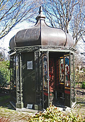
Waymouth sold the property to Annie Quayle Townend[6] in 1905, who renamed it to Mona Vale after her mother's house in Tasmania. She was the daughter of a wealthy Canterbury run-holder, George Moore. She was his only daughter and he had bequeathed her one million pounds, apparently making her New Zealand's richest woman at the time.[6] Townend added nine acres of land to the property[7] and had a gate house built just off Fendalton Road. After the New Zealand International Exhibition, held in Hagley Park, finished in 1907, she purchased the exhibitions fernery including its plants and had it reassembled at Mona Vale.[2] The present collection of ferns were supplied by Landcare Research in Lincoln, the Christchurch Botanic Gardens and the private collection of the late Arthur Ericson.[8] Townend also added the bathhouse to the property.[6] She died in 1914.[2]
The property was sold in 1962 to the Church of the Latter Day Saints. When the church intended to subdivide the property and to demolish the homestead, a public outcry resulted in community fund-raising.[2] The Christchurch City Council and the Riccarton Borough Council bought Mona Vale in June 1969 for the purpose of turning it into a public park.[9] The purchase of Mona Vale is credited to Christchurch mayor Ron Guthrey.[10]
Until the 2010 Canterbury earthquake, the homestead was operated as a restaurant, café and function centre, often used for weddings.[2][11] The building is currently closed due to earthquake damage.[12]
Heritage listings
The homestead was registered as a Category I heritage building by the NZHPT on 7 April 1983 with registration number 283.[2] The gate house off Fendalton Road has its own heritage listing, and it was registered by NZHPT as Category II on 23 June 1983 with registration number 1799.[13]
- Photo gallery
References
- ^ "About". Christchurch Girls' High School. http://www.chgirls.school.nz/about. Retrieved 2 July 2011.
- ^ a b c d e f g h "Mona Vale". Register of Historic Places. New Zealand Historic Places Trust. http://www.historic.org.nz/TheRegister/RegisterSearch/RegisterResults.aspx?RID=283&m=advanced. Retrieved 2 July 2011.
- ^ "Mona Vale". NZine. 23 May 1998. http://www.nzine.co.nz/features/monavale.html. Retrieved 2 July 2011.
- ^ "William Derisley Wood". The Press. http://www.firstfourships.co.nz/pics/person.php?pos=r14. Retrieved 3 July 2011.
- ^ "Dam built for the Riccarton Mill, forming the Mona Vale mill pond". Christchurch City Libraries. http://christchurchcitylibraries.com/Heritage/Photos/Disc4/IMG0019.asp. Retrieved 3 July 2011.
- ^ a b c d "The Gate House - MONA VALE". Older & Bolder. http://www.olderandbolder.co.nz/showthread.php?111-The-Gate-House-MONA-VALE. Retrieved 3 July 2011.
- ^ a b "Unsung Heroines - Annie Quayle Townend". Christchurch City Libraries. http://christchurchcitylibraries.com/Heritage/Publications/UnsungHeroines/AnnieQuayleTownend/. Retrieved 3 July 2011.
- ^ "Mona Vale fernery". Christchurch City Council. http://www.ccc.govt.nz/cityleisure/parkswalkways/trees/protectednotabletrees/monavalefernery.aspx. Retrieved 3 July 2011.
- ^ "1969". Christchurch City Libraries. http://christchurchcitylibraries.com/Heritage/Chronology/Year/1969.asp. Retrieved 3 July 2011.
- ^ "Albert Ronald Guthrey 1916 - 2008". Christchurch City Libraries. http://christchurchcitylibraries.com/Heritage/People/GuthreyRon/. Retrieved 3 July 2011.
- ^ "Mona Vale". Christchurch City Libraries. http://christchurchcitylibraries.com/Heritage/Places/Public/MonaVale/. Retrieved 3 July 2011.
- ^ "MONA VALE IS CLOSED DUE TO THE RECENT EARTHQUAKE IN CHRISTCHURCH". Continental. http://www.monavale.co.nz/. Retrieved 3 July 2011.
- ^ "Mona Vale gate house". Register of Historic Places. New Zealand Historic Places Trust. http://www.historic.org.nz/TheRegister/RegisterSearch/RegisterResults.aspx?RID=1799&m=advanced. Retrieved 2 July 2011.
External links
Categories:- 1899 establishments in New Zealand
- Parks in New Zealand
- Urban public parks
- Geography of Christchurch
- Visitor attractions in Christchurch
- NZHPT Category I listings in the Canterbury Region
- NZHPT Category II listings in the Canterbury Region
Wikimedia Foundation. 2010.


