- Mischabel Hut
-
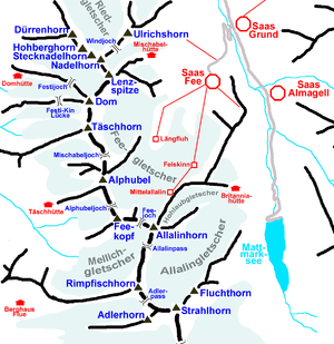 Map of the Mischabel range
The Mischabel Hut (German: Mischabelhütte) is a mountain hut located east of the Dom. It is situated at 3,340 metres (10,960 ft) above sea level, in the Saastal valley near Saas Fee, in the Swiss canton of Valais. The hut is owned by the Akademische Alpen-Club Zürich (AACZ).
The hut is accessible to experienced hikers from Saas Fee (4 hours), with a marked trail and fixed ropes. The Mischabel Hut is used to climb the Lenzspitze, Nadelhorn and Hohberghorn.
External links
- "Official website" (in German). http://www.ssf.ch/cms/index.php?option=com_content&task=view&id=18&Itemid=33. Retrieved 2011 November 08.
- "Mischabel Hut". SummitPost.org. http://www.summitpost.org/hut/campground/266410/mischabel-hut.html. Retrieved 2011 November 08.
Categories:- Mountain huts in Switzerland

Wikimedia Foundation. 2010.