- Międzyodrze-Wyspa Pucka
-
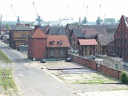
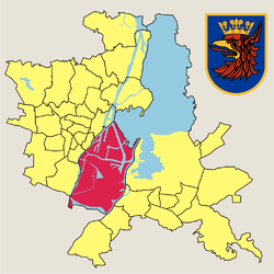
Międzyodrze-Wyspa Pucka — Municipal neighbourhood — Port buildings in Międzyodrze-Wyspa Pucka Location of Międzyodrze-Wyspa Pucka within Szczecin Coordinates: 53°24′N 14°34′E / 53.4°N 14.567°ECoordinates: 53°24′N 14°34′E / 53.4°N 14.567°E Country  Poland
Voivodeship West Pomeranian County/City Szczecin Population (2011) – Total 1,098 Time zone CET (UTC+1) – Summer (DST) CEST (UTC+2) Postal code Area code(s) +48 91 Car plates ZS Międzyodrze-Wyspa Pucka is a municipal neighbourhood of the city of Szczecin, Poland situated on the islands between the West Oder river and East Oder River (Regalica), south-east of the Szczecin Old Town, and west of Szczecin-Dąbie. As of January 2011 it had a population of 1,098.[1]
References
- ^ "Zestawienie informacyjne o liczbie osób zameldowanych w Szczecinie" (in Polish). Urząd Miasta Szczecin. http://bip.um.szczecin.pl/umszczecinbip/chapter_50049.asp. Retrieved 2011-01-23.
Szczecin Districts Śródmieście
(Centre)Centrum • Drzetowo-Grabowo • Łękno • Międzyodrze-Wyspa Pucka • Niebuszewo-Bolinko • Nowe Miasto • Stare Miasto • Śródmieście-Północ • Śródmieście-Zachód • TurzynPółnoc
(North)Bukowo • Golęcino-Gocław • Niebuszewo • Skolwin • Stołczyn • Warszewo • ŻelechowaZachód
(West)Arkońskie-Niemierzyn • Głębokie-Pilchowo • Gumieńce • Krzekowo-Bezrzecze • Osów • Pogodno • Pomorzany • Świerczewo • Zawadzkiego-KlonowicaPrawobrzeże
(Right bank) Categories:
- Neighbourhoods of Szczecin
- West Pomeranian geography stubs
Wikimedia Foundation. 2010.


