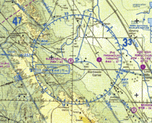
- Maximum elevation figure
-
Maximum elevation figure or MEF is the highest feature within an area. It is of interest to pilots so they can fly above mountain peaks and tall towers without the worry of flying into them. Features include terrain, trees, towers, and the like.
In the US, the Federal Aviation Administration issues sectional charts. Each rectangular area covering one degree of latitude and one degree of longitude is divided into four smaller areas called quadrangles, each spanning half a degree of latitude and half a degree of longitude. Each quadrangle has its MEF printed in it in thousands and hundreds of feet above mean sea level. For example, 105, means that the highest elevation is 10,500 feet within that quadrangle.
MEFs are determined by taking the point of highest elevation within a quadrangle, adding 100 feet for vertical error, then adding the height of the highest obstacle in the quadrangle or 200 feet, whichever is higher, then rounding up to the next hundred feet.[1]
References
- ^ "Explanation of VFR Terms and Symbols". Federal Aviation Administration. http://aeronav.faa.gov/content/aeronav/online/pdf_files/VFR_Intro_9thEd.pdf. Retrieved 27 February 2011.
Categories:- Aviation terminology
- Cartography
- Highest points
- Aviation terminology stubs
- Cartography stubs
Wikimedia Foundation. 2010.

