- Mashike Mountains
-
Mashike Mountains (増毛山地 Mashike Sanchi) Range 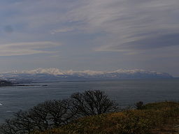 View from Obira (April 2009)
Country Japan State Hokkaidō Regions Ishikari, Rumoi, Sorachi Parts Kabato Mountains, Shokanbetsudake Mountains Highest point Mount Shokanbetsu - location Mashike and Shintotsukawa, Rumoi and Sorachi Subprefecture, Japan - elevation 1,491.6 m (4,894 ft) - coordinates 43°42′57″N 141°31′23″E / 43.71583°N 141.52306°E Biome alpine climate Geology Volcanic and fold Orogeny island arc Mashike Mountains (増毛山地 Mashike Sanchi) are a group mountains on the western coast of Hokkaidō. The mountain range is divided into two regions by the Hamamasu River.[1] The northern region is a group of volcanic mountains called Shokanbetsudake Mountains.[2]. The southern region is known as the Kabato Mountains.[1] The Mashike mountains lie between the Teshio Mountains to the north and the Ishikari Plain to the south. Mashikie mountains includes part of Shokanbetsu-Teuri-Yagishiri Quasi-National Park.[2]
The highest peak of the Mashike mountains is Mount Shokanbetsu (1492m). [2]
Mount Minami Shokan, Mount Kunbetsu and Mount Etai define a triangle that surrounds the Uryū Wetlands (雨竜沼湿原 Uryūnumashitsugen).[2]
Flora and fauna
Unlike on Honshū, you can see alpine plants at altitudes as low as 1000 meters in the Mashike mountains.[3]
References
- ^ a b "厚田・浜益の自然" (in Japanese). 石狩ファイル No.0052-01. 石狩市教育委員会. 2006-03-31. http://www.city.ishikari.hokkaido.jp/content/000005823.pdf. Retrieved 8 May 2010.
- ^ a b c d "暑寒別天売焼尻国定公園 Shokanbetsu Teuri Yagishiri Quasi National Park" (in Japanese). Mashike Town Web Site. 増毛町役場. http://www.town.mashike.hokkaido.jp/menu/kanko/syokanpark/sypark.html. Retrieved 3 May 2010.
- ^ "暑寒別岳" (in Japanese). Mashike Town Web Site. 増毛町役場. http://www.town.mashike.hokkaido.jp/menu/kanko/Mt.syokan/mtsyok.html. Retrieved 3 May 2010.
Categories:- Mountains of Hokkaidō
- Mountain ranges of Japan
- Hokkaidō geography stubs

Wikimedia Foundation. 2010.