- Maschaug Pond
-
Maschaug Pond 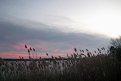
seen from the Ocean View Highway Location Westerly, Washington County, Rhode Island Group Salt Ponds of Rhode Island Coordinates 41°19′07″N 71°49′51″W / 41.3187110°N 71.8309015°WCoordinates: 41°19′07″N 71°49′51″W / 41.3187110°N 71.8309015°W Lake type coastal lagoon, brackish Primary inflows precipitation, groundwater Catchment area 392.57 acres (158.87 ha) Basin countries United States Surface area 34.63 acres (14.01 ha) Average depth 6.89 ft (2.10 m) Maschaug Pond is a coastal lagoon in Westerly, Washington County, Rhode Island, United States.[1] Located at 41°19′07″N 71°49′51″W / 41.3187110°N 71.8309015°W, it is one of nine such lagoons (often referred to as "salt ponds") in southern Rhode Island.[2] A "small, brackish pond",[1] it is not permanently connected to the Block Island Sound, and is largely bordered by a golf course.[3] Nests of the federally threatened Piping Plover have been documented within the watershed.[4]
Its watershed covers 392.57 acres (158.87 ha); 52.08 acres (21.08 ha) is occupied by water. Maschaug itself has a surface area of 34.63 acres (14.01 ha), while nearby Little Maschaug Pond is 11.69 acres (4.73 ha). The pond averages 6.89 ft (2.10 m) deep, and has a salinity level of approximately 7 parts per thousand, too low to sustain the growth of eelgrass.[2][5] The pond is non-tidal, except when breached by storms.[5] The water directly receives about 57,219,222 gallons of precipitation per year, though groundwater flow is unknown. No rivers or streams flow into the pond.[6] Maschaug Pond, like others in the region, was "formed after the recession of the glaciers 12,000 years ago".[7]
As a result of certain environmental conditions, including low elevation of surrounding land and dense residential and commercial development, Maschaug Pond is considered particularly susceptible to storm surge. It is projected that during a future hurricane, Winnapaug and Maschaug Ponds will likely be significantly changed.[4]
See also
- List of lakes in Rhode Island
- Geography of Rhode Island
References
- ^ a b "Salt Ponds of Rhode Island". Rhode Island Sea Grant. http://seagrant.gso.uri.edu/bookstore/saltpond.pdf. Retrieved 2009-05-25.[dead link]
- ^ a b S.W. Nixon and B. A. Buckley (2007). "Nitrogen Inputs to Rhode Island Coastal Salt – Too Much of a Good Thing". Rhode Island Department of Environmental Management. http://www.dem.ri.gov/programs/benviron/water/permits/isds/pdfs/spnload.pdf. Retrieved 2009-05-25.
- ^ Peter Lord (January 9, 2005). "Shifting sands". The Providence Journal. http://www.projo.com/fishing/content/projo_20050109_ninigret.a4308.html. Retrieved 2009-06-11.
- ^ a b "Rhode Island’s Salt Pond Region: A Special Area Management Plan". Rhode Island Coastal Resources Management Council. http://www.crmc.ri.gov/regulations/SAMP_SaltPond.pdf. Retrieved 2009-06-11.
- ^ a b "Maschaug Pond General Features Data". Rhode Island South Shore Sea Grant. http://seagrant.gso.uri.edu/coasts/maschaug/maschaugGFD.html. Retrieved 2009-06-11.[dead link]
- ^ "Maschaug Pond Freshwater Input Data". Rhode Island South Shore Sea Grant. http://seagrant.gso.uri.edu/coasts/maschaug/maschaugFID.html. Retrieved 2009-06-11.[dead link]
- ^ "What is a Salt Pond?". Salt Ponds Coalition. http://www.saltpondscoalition.org/pond%20profiles.html. Retrieved 2009-06-11.
External links
- U.S. Geological Survey Geographic Names Information System: Maschaug Pond
- U.S. Environmental Protection Agency: National Assessment Database 2008 Waterbody Report for Maschaug Pond
- Maschaug Pond map
- Water quality
Rhode Island's salt ponds 
Point Judith Pond • Potter Pond • Trustom Pond • Cards Pond • Ninigret Pond • Green Hill Pond • Quonochontaug Pond • Winnapaug Pond • Maschaug Pond Categories:- Landforms of Washington County, Rhode Island
- Lakes of Rhode Island
- Saline lakes
- Westerly, Rhode Island

Wikimedia Foundation. 2010.