- Martholme Viaduct
-
Martholme Viaduct 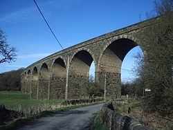
Engineering design Sturges Meek Material Sandstone Height 65 feet (20 m) Number of spans 10 Construction begin 1870 Construction end 1877 Heritage status Grade II listed building Coordinates 53°48′01″N 2°22′44″W / 53.8004°N 2.3788°WCoordinates: 53°48′01″N 2°22′44″W / 53.8004°N 2.3788°W Martholme Viaduct is a 19th-century railway viaduct in the English county of Lancashire. It lies between the town of Great Harwood and the village of Read, and belongs to both the district of Hyndburn and that of Ribble Valley.[1] The viaduct was constructed 1870–77 by engineer Sturges Meek.[2] It was built to carry the Great Harwood Loop of the East Lancashire Line over the River Calder.[3] That part of the line closed in 1957.[2]
The viaduct was originally intended to be a wooden structure but was eventually built of sandstone rubble.[2] It has ten round arches, each 40 feet (12 m) wide. On a slight curve, the viaduct is 65 feet (20 m) high.[3] In 1984 it was designated a Grade II listed building by English Heritage.[2]
See also
References
- Footnotes
- ^ "Martholme Viaduct (That Part in the Civil Parish of Read)", National Heritage List for England (English Heritage), http://list.english-heritage.org.uk/resultsingle.aspx?uid=1072078, retrieved 7 August 2011
- ^ a b c d "Martholme Viaduct", National Heritage List for England (English Heritage), http://list.english-heritage.org.uk/resultsingle.aspx?uid=1362005, retrieved 7 August 2011
- ^ a b Hartwell & Pevsner, p. 310
- Bibliography
- Hartwell, Clare; Pevsner, Nikolaus (2009) [1969], Lancashire: North, New Haven and London: Yale University Press, ISBN 0300126670
External links
 Media related to Martholme Viaduct at Wikimedia Commons
Categories:- Bridges completed in 1877
- Bridges in Lancashire
- Buildings and structures in Hyndburn
- Buildings and structures in Ribble Valley
- Grade II listed buildings in Lancashire
- Stone bridges
- Viaducts in the United Kingdom

Wikimedia Foundation. 2010.