Markarfljót

Markarfljót
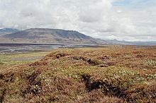
Markarfljót near Þórsmörk with Þórólfsfell in the background
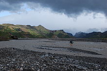
Wading of Krossá river

Markarfljót is a river in the south of Iceland. It is approximately 100 kilometers long.

The Markarfljót rises in the Rauðafossafjöll massif, east of the volcano Hekla. The main sources for the river are the glaciers Mýrdalsjökull and Eyjafjallajökull. It flows through narrow gorges in the mountainous area between the glaciers Tindfjallajökull and Torfajökull, then spreads in the wide sandur plains at Iceland's south coast, near Þórsmörk. The Markarfljót takes its course first north, then west of Þórsmörk and finally empties into the Atlantic west of Eyjafjallajökull.

One of the Markarfljót's tributaries is the river Krossá, flowing through Þórsmörk, which is notorious for sudden changes in its water level.

The highest discharge ever measured in the Markarfljót was 2,100 m3/s (74,000 cu ft/s) in 1967, during the Steinholt jökulhlaup.

The first bridge over the river was opened in 1934 near Litli Dímon. It is 242 meters long and was at the time the longest bridge in Iceland. A second bridge was built in 1978 at Emstrur. A third bridge was opened in 1992 a few kilometers south of the first bridge.[1]

References

  1. ^ http://www.utivist.is/skalar/basar_a_godalandi/leidarlysing_inn_ad_godalandi/

Coordinates: 63°57′5″N 19°21′31″W / 63.95139°N 19.35861°W / 63.95139; -19.35861


Wikimedia Foundation. 2010.

Игры ⚽ Поможем написать курсовую

Look at other dictionaries:

  • Markarfljót — Oberer Markarfljót mit dem Gletscher Myrdalsjökull, links. Aussicht von Norden nach SüdenVorlage:Infobox Fluss/KARTE fehlt …   Deutsch Wikipedia

  • Markarfljót — entre les glaciers Mýrdalsjökull et Tindfjallajökull Caractéristiques Longueur ≈ 100 km  …   Wikipédia en Français

  • Markarfljot — Markarfljót Markarfljót est un fleuve dans le sud de l’Islande. Les eaux de ce fleuve proviennent surtout des glaciers Mýrdalsjökull et Eyjafjallajökull. Le fleuve est déjà assez grand à ses débuts. Il fut situé à l’est du Eyjafjallajökull dans… …   Wikipédia en Français

  • Markarfljót — Vista del Markarfljót cerca de Þórsmörk, junio de 2005. País que atraviesa …   Wikipedia Español

  • Markarfljot — Krossá im Vorder , Markarfljót im Hintergrund Der Markarfljót unweit der Þórsmörk Der Markarfljót ist ein Fluss im Süden Islands. Er entspringt im Gebirgsmassiv der Rauðafossafjöll, östlich der …   Deutsch Wikipedia

  • Eyjafjallajökull — Höhe 1.666  …   Deutsch Wikipedia

  • Krossá (Rangárvatnssýsla) — Sicht über die Krossáebene zum Markarfljót Der Krossá ist ein Nebenfluss des Markarfljót in Südisland und entspringt im Gletscher Krossárjökull, einem Arm des Mýrdalsjökull. Danach fließt er zwischen dem Gletscher Eyjafjallajökull und der… …   Deutsch Wikipedia

  • Ausbruch des Eyjafjallajökull 2010 — Der Ausbruch des Vulkans Eyjafjallajökull (  [ˈɛɪjaˌfjatlaˌjœkʏtl̥]) im Jahr 2010 begann am 20. März 2010. Ausbruchsstelle am Fimmvörðuhá …   Deutsch Wikipedia

  • Fleuves d'Islande — Liste des cours d eau d Islande Les fleuves sur une île comme l Islande ne sont pas très longs. Mais quelques uns sont néanmoins assez connus. Liste des cours d eau islandais les plus importants, ordonnés par longueur décroissante : Le… …   Wikipédia en Français

  • Liste des cours d'eau d'Islande — Les fleuves sur une île comme l Islande ne sont pas très longs. Mais quelques uns sont néanmoins assez connus. Liste des cours d eau islandais les plus importants, ordonnés par longueur décroissante : Le Þjórsá …   Wikipédia en Français

Share the article and excerpts

Direct link
Do a right-click on the link above
and select “Copy Link”