- Manzini, Swaziland
-
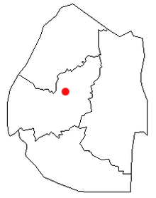 Location of Manzini in Swaziland
Manzini is Swaziland's largest urban centre, known as "The Hub" of Swaziland. Swaziland's primary industrial site at Matsapha lies near the town's western border. Population is 73,000 (2004). Known as Bremersdorp until 1960, tt is the capital of the Manzini District.
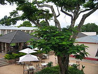 Ex Tum's George Hotel in Manzini
A commercial centre from the time a trading post was opened in 1885, Bremersdrop was designated a township in 1898. Arthur Bremer sold his hotel for use as British Colonial authorities who had administered Swaziland since 1894 as their national administrative headquarters, and stipulated that the settlement would bear his name. "Dorp" is the Afrikaans word for "small town." The name reverted to its original Swazi name, Manzini, in 1960.
The town was a British/Boer colonial headquarters from 1890 but was destroyed in 1902 amid the Anglo-Boer War, when the administrative centre was transferred to Mbabane. However, Bremersdorp (later Manzini) subsequently remained the commercial, agricultural and transportation heart of Swaziland, earning the town the nickname "The Hub." Since its inception in the 1920s, the Agricultural Show (name later changed to the Swaziland International Trade Fair) has been the country's largest and best-attended annual event.
Residential areas radiate outward from the Central Business District. At the western terminous of the city on the highway to Mbabane is KaKhoza Township, a poor neighborhood with the appearance of an informal settlement. North of downtown beyond the Mavuso International Trade Fair (opened 2004) along a bypass road (opened 1994, rebuilt 2004 for the opening of the Mavuso Trade Fair) is Helemesi Estates. Here middle-class dwellings were erected in the early 1990s on the former farm of Sydney Williams, the long-serving Resident Commissioner during British rule. Helemesi is the SiSwati corruption of the name Williams. The housing development is surrounded by Fairview Township, developed in 1964 during the twilight of colonial rule as Swaziland's first integrated residential neighbourhood. 19th century law, reaffirmed by ordinances in the 1920s, forbade Swazis from residing or owning businesses in Bremserdorp. Until the 1960s Swazi business proprietors used Europeans as fronts in order to operate "Native Eating Houses" and other establishments.
The popularity of Fairview Township prompted the expansion of the area north of a hill occupied at its summit by St. Paul's Methodist Church and School, beside a landmark water tower. The newer development was named Fairview North and the original development became Fairview South.
Upscale residential neighbourhoods were erected to the east of downtown, beginning with Coates Valley in the 1960s. Extension 6 north of Coates Valley is predominately middle class homes, and abuts a planned community of up-market properties, Madonsa Township. Large homes were erected at Madonsa Township from the 1990s until all lots were developed ten years later.
South of downtown is the sprawling lower and middle-class Ngwane Park Township, developed from a private farm since the 1970s. However, most areas surrounding Manzini are rural Swazi Nation Land administered by chiefs.
Manzini has its pockets of extreme poverty: informal settlements along the river, east of Coates Valley, and west between KaKhoza Township and the industrial town Matsapha.
In 1915, the first hotel since Bremersdorp's post-Anglo/Boer War reconstruction was opened on the banks of the Mzimene River. Named the Riverside Hotel, it remained opened until 1997, changing its name over the years to the Manzini Arms Hotel and in the 1990s the Velebantfu Hotel. The buildings were intact after closure for several years, but were leveled in 2008 by private developers. A shopping mall opened on the site in 2011.
Opened in the 1970s, Matsapha International Airport, Swaziland's only commercial airport, lies 10 km. to the west. Under construction in Sikhupe, 60 km east, is a new international airport. Manzini is the closest urban centre.
Manzini was declared a city in 1994, when its administrative apparatus, the Manzini Town Council, became the Manzini City Council.
Manzini is home to a Nazarene High School, which has a successful school choir. [1]
Town twinning
References
- ^ Manzini Nazarene tops them all by Bongile Mavuso, The Swazi Observer August 2, 2007
- Hall, James "Speak Manzini: An Autobiography of an African City" (Swaziland, Landmark Publishers, 2000)
Matsebula, J.S.M. "A History of Swaziland" (Cape Town, South Africa, Longman South Africa, 1972)
Categories:- Populated places in Swaziland
- Swaziland geography stubs

Wikimedia Foundation. 2010.