Manchester Cenotaph

Manchester Cenotaph
Cenotaph, St Peter's Square

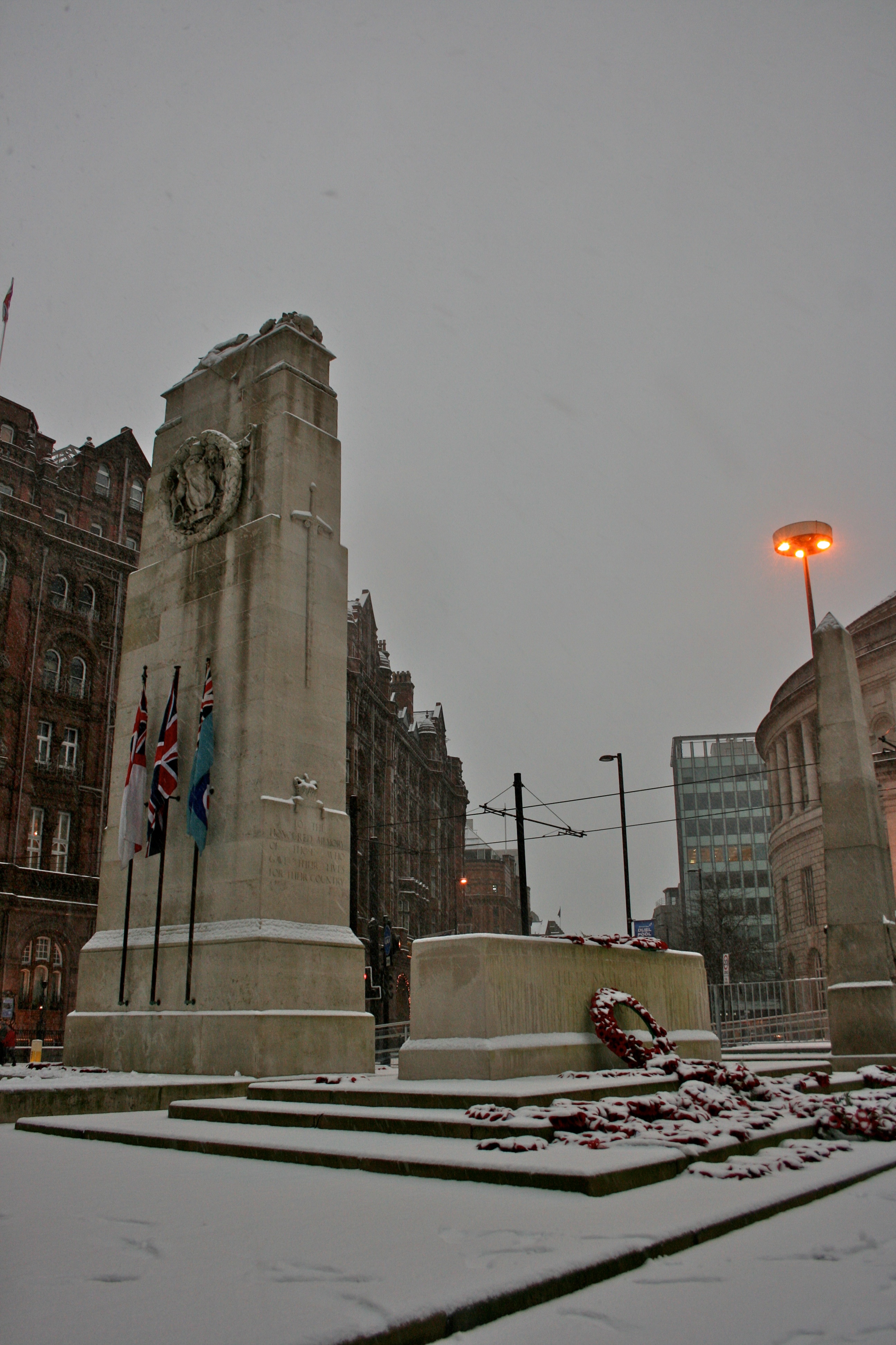
The Manchester Cenotaph in St Peter's Square, Manchester, England, was designed by Sir Edwin Lutyens. Built in Portland stone, it was erected in 1924 as a memorial to those who lost their lives in the First World War. It is similar to the cenotaph designed by Lutyens for Whitehall; "a pylon in diminishing stages with a figure of the Unknown Soldier draped in a greatcoat on top".[1] The cenotaph sits in a memorial garden designed by L. C. Howitt, which also contains a stone cross commemorating the Church of St Peter, built in 1789–94 by James Wyatt and demolished in 1907.[2] The north-east side of the memorial bears the inscription: TO THE HONOURED MEMORY OF THOSE WHO GAVE THEIR LIVES FOR THEIR COUNTRY. On the south west side the inscription is: O LORD GOD OF OUR FATHERS KEEP FOR EVER IN THE IMAGINATION OF THE THOUGHTS OF THE HEART OF THY PEOPLE. The Cenotaph was designated a Grade II* listed building on 3 September 1974.[3]

During March 2011, Manchester City Council announced a consultation on moving the cenotaph to an alternative site within St Peter's Square in order for the nearby Metrolink station to be expanded.[4]

Notes

  1. ^ Hartwell (2002) p. 202.
  2. ^ Hartwell, Hyde, and Pevsner (2004) p. 332.
  3. ^ "War Memorial, Manchester". British Listed Buildings. http://britishlistedbuildings.co.uk/en-457622-war-memorial-manchester. 
  4. ^ "Manchester's cenotaph 'could be moved'". BBC News. 8 March 2011. http://www.bbc.co.uk/news/uk-england-manchester-12676749. 

References

  • Hartwell, Clare (2002). Manchester. Pevsner Architectural Guides. London: Penguin. ISBN 978-0-14-071131-8. 
  • Hartwell, Clare; Hyde, Matthew; Pevsner, Nikolaus (2004). Lancashire: Manchester and the South-East. The Buildings of England. New Haven;London: Yale University Press. ISBN 0-300-10583-5. 

Coordinates: 53°28′39″N 2°14′38″W / 53.4776°N 2.2438°W / 53.4776; -2.2438


Wikimedia Foundation. 2010.

Игры ⚽ Поможем написать реферат

Look at other dictionaries:

  • Manchester city centre — Coordinates: 53°28′45″N 2°14′39″W / 53.479167°N 2.244167°W / 53.479167; 2.244167 …   Wikipedia

  • Manchester — This article is about the city of Manchester in England. For the wider metropolitan county, see Greater Manchester. For the larger conurbation, see Greater Manchester Urban Area. For other uses, see Manchester (disambiguation). Coordinates …   Wikipedia

  • Atherton, Greater Manchester — Coordinates: 53°31′23″N 2°29′42″W / 53.523°N 2.495°W / 53.523; 2.495 …   Wikipedia

  • Hyde, Greater Manchester — Coordinates: 53°26′51″N 2°04′55″W / 53.4474°N 2.0820°W / 53.4474; 2.0820 …   Wikipedia

  • Denton, Greater Manchester — Coordinates: 53°27′19″N 2°06′44″W / 53.4554°N 2.1122°W / 53.4554; 2.1122 …   Wikipedia

  • Sale, Greater Manchester — infobox UK place country = England static static image caption=Sale Town Hall latitude= 53.424 longitude= 2.322 official name= Sale population = 55,234 (2001 census) population density=12,727 per mi² (4,914 per km²) metropolitan borough= Trafford …   Wikipedia

  • Tottington, Greater Manchester — infobox UK place country = England map type= Lancashire latitude= 53.6132 longitude= 2.3393 official name= Tottington population= 9,389Fact|date=April 2007 metropolitan borough= Bury metropolitan county= Lancashire region= North West England… …   Wikipedia

  • Middlewich — Coordinates: 53°11′31″N 2°26′35″W / 53.192°N 2.443°W / 53.192; 2.443 …   Wikipedia

  • 2010 UK student protests — The official logo for the demonstration on 10 November. The 2010 UK student protests were a series of demonstrations that began in November 2010 in several areas of the United Kingdom, with the focal point of protests centred in London. The… …   Wikipedia

  • Ashton-under-Lyne — infobox UK place country = England latitude = 53.4941 longitude = 2.1032 population= 43,236 (2001 Census) population density=12,374 per mi² (4,777 per km²) official name= Ashton under Lyne metropolitan borough= Tameside region = North West… …   Wikipedia

Share the article and excerpts

Direct link
Do a right-click on the link above
and select “Copy Link”