- Maja Valles
-
Maja Valles
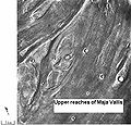
Waters from Vedra Vallis, Maumee Vallis, and Maja Valles went from Lunae Planum on the left, to Chryse Planitia on the right. Image is located in Lunae Palus quadrangle and was taken by Viking Orbiter.Coordinates 12°36′N 58°18′W / 12.6°N 58.3°WCoordinates: 12°36′N 58°18′W / 12.6°N 58.3°W Maja Valles is a large, ancient outflow channel in the Lunae Palus quadrangle on Mars. Its location is 12.6° north latitude and 58.3° west longitude. The name is a Nepali word for "Mars".[1] Maja Valles begins at Juventae Chasma. Parts of the system have been partially buried by thin volcanic debris. Maja Valles ends at Chryse Planitia.[2]
Huge outflow channels were found in many areas by the Viking Orbiters. They showed that floods of water broke through dams, carved deep valleys, eroded grooves into bedrock, and traveled thousands of kilometers.[3][4][5]
-
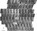
Area around Northern Kasei Valles, showing relationships among Kasei Valles, Bahram Vallis, Vedra Vallis, Maumee Vallis, and Maja Valles. Map location is in Lunae Palus quadrangle and includes parts of Lunae Planum and Chryse Planitia.
-
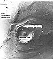
Tear-drop shaped islands caused by flood waters from Maja Valles, as seen by Viking Orbiter. Image is located in Oxia Palus quadrangle.
-
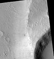
Maja Valles Streamlined Island, as seen by HiRISE. Island formed behind the impact crater at the lower right.
References
- ^ http://planetarynames.wr.usgs
- ^ Baker, V. 1982. The Channels of Mars. University of Texas Press. Austin
- ^ ISBN 0-8165-1257-4
- ^ Raeburn, P. 1998. Uncovering the Secrets of the Red Planet Mars. National Geographic Society. Washington D.C.
- ^ Moore, P. et al. 1990. The Atlas of the Solar System. Mitchell Beazley Publishers NY, NY.
Categories:- Lunae Palus quadrangle
- Valleys and canyons on Mars
- Mars stubs
-
Wikimedia Foundation. 2010.


