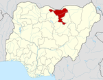
- Maigatari
-
Maigatari — LGA and town — Country  Nigeria
State Jigawa State Time zone WAT (UTC+1) Maigatari is a Local Government Area in the north of Jigawa State, Nigeria, bordering on the Republic of Niger. Its headquarters are in the town of Maigatari.
It has an area of 870 km² and a population of 179,715 at the 2006 census.
The postal code of the area is 732.[1]
References
- ^ "Post Offices- with map of LGA". NIPOST. http://www.nipost.gov.ng/PostCode.aspx. Retrieved 2009-10-20.
 Jigawa State
State capital: Dutse LGAs Auyo · Babura · Biriniwa · Birnin Kudu · Buji · Dutse · Gagarawa · Garki · Gumel · Guri · Gwaram · Gwiwa · Hadejia · Jahun · Kafin Hausa · Kazaure · Kiri Kasama · Kiyawa · Kaugama · Maigatari · Malam Madori · Miga · Ringim · Roni · Sule Tankarkar · Taura · Yankwashi
 Categories:
- Local Government Areas in Jigawa State
- Populated places in Jigawa State
- Nigeria geography stubs
Wikimedia Foundation. 2010.
