- Duncan Canal (Alaska)
-
Coordinates: 56°38′23″N 133°06′43″W / 56.63972°N 133.11194°W
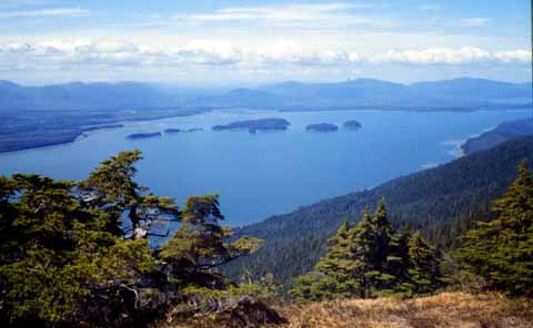
 View from Lindenberg Peninsula looking northwest up Duncan Canal towards Kupreanof Mountain.
The Duncan Canal is a naturally occurring inland waterway in the Alexander Archipelago in Alaska, USA. It deeply penetrates Kupreanof Island, separating the Lindenberg Peninsula, on the southeast side of the island from the main island. It was first charted in 1793 by James Johnstone, one of George Vancouver's officers during his 1791-95 expedition.[1] It was named after the English missionary William Duncan.
The Duncan Canal Portage is a popular hiking trail across the northern end of the Lindenberg Peninsula. It originally provided access to the northern end of the Duncan Canal directly from Frederick Sound.
Butterworth Island is located at the mouth of the Duncan Canal where it debouches into the Sumner Strait past the larger Woewodski Island.
References
- ^ Vancouver, George, and John Vancouver (1801). A voyage of discovery to the North Pacific ocean, and round the world. London: J. Stockdale. http://books.google.com/books?id=qwol8bPaYxsC&printsec=frontcover&source=gbs_ge_summary_r&cad=0#v=onepage&q&f=false.
External links
- Wright, Fred Eugene and Wright, Charles Will (1908) "Duncan Canal" The Ketchikan and Wrangell Mining Districts, Alaska Bulletin 347, United States Geological Survey, Government Printing Office, Washington, D.C., pp. 140-142, OCLC 4174766
- Karl, Susan M.; Haeussler, Peter J. and McCafferty, Anne (1999) "Reconnaissance Geologic Map of the Duncan Canal-Zarembo Island Area, Southeastern Alaska" U.S. Geological Survey Open-File Report 99-168.
- "Duncan Canal", text and pictures of radio installation at Indian Point, Duncan Canal, from Internet Archive
- "Duncan Canal Volcano Satellite Images - ASTER Volcano Archive" NASA
- "Duncan Canal Webcam" from Bay TV
Categories:- Alexander Archipelago
- Landforms of Petersburg Census Area, Alaska
- Straits of Alaska
- Southeast Alaska geography stubs
Wikimedia Foundation. 2010.