Dryhill

Dryhill

Dryhill is a small hamlet in the Sevenoaks District, in the county of Kent.

Contents

Location

It is about two miles away from the large town of Sevenoaks, located near the A25 road between Sevenoaks and Sundridge, Kent.

Transport

For transport there is the Sevenoaks railway station and the A25 road road, the M25 motorway, M20 motorway and the M26 motorway nearby.

Local Nature Reserve

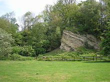
Natural Ragstone Outcrop in Dryhill Nature Reserve

The Dryhill Local Nature Reserve based on an old ragstone quarry at the edge of the village covers some 20 hectares (50 acres).[1] It is managed by Kent Country Council, as a Country Park and picnic area.[2]

References

  • A-Z Great Britain Road Atlas (page 181)

Coordinates: 51°16′29″N 0°08′35″E / 51.2748°N 0.1430°E / 51.2748; 0.1430


Wikimedia Foundation. 2010.

Игры ⚽ Поможем написать реферат

Look at other dictionaries:

  • Hell for Certain, Kentucky — Hell for Certain is an unincorporated area in Leslie County, Kentucky, United States. The unincorporated town of Dryhill, (37.1546° North, 83.4157° West), is the proper name of Hell for Certain, located seven miles north of the small town of… …   Wikipedia

  • List of road junctions in the United Kingdom: D — Lists of United Kingdom road junctions: 0–A B C D E F G H I–K L M N O P Q R S T U–V W X–Z …   Wikipedia

  • River Medway — For similarly named rivers, see Medway River (disambiguation). Coordinates: 51°26′57″N 0°44′18″E / 51.44917°N 0.73833°E / 51.44917; 0.73833 …   Wikipedia

  • Tonbridge — infobox UK place country = England official name= Tonbridge static static image caption=Tonbridge Castle latitude= 51.1987 longitude= 0.2764 population = 30,340 (2007) shire district= Tonbridge and Malling shire county = Kent region= South East… …   Wikipedia

  • List of Registered Historic Places in Kentucky (Jackson County to Lyon County) — List of Registered Historic Places in Kentucky (Jackson County to Lyon County). Links in italic lead to a new page. NOTOC :: Kentucky NRHP date for lists This list is intended to provide a comprehensive listing of Registered Historic Places… …   Wikipedia

  • Cobham Woods — Site of Special Scientific Interest Area of Search Kent Grid reference TQ699686 Interest Biological Area 235.2 Hectares (581.2 acres) …   Wikipedia

  • Dungeness, Romney Marsh and Rye Bay — Site of Special Scientific Interest …   Wikipedia

  • National Register of Historic Places listings in Leslie County, Kentucky — Location of Leslie County in Kentucky This is a list of the National Register of Historic Places listings in Leslie County, Kentucky. It is intended to be a complete list of the properties on the National Register of Historic Places in Leslie… …   Wikipedia

Share the article and excerpts

Direct link
Do a right-click on the link above
and select “Copy Link”