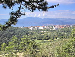
- Drenova
-
Drenova — local district — Drenova and Rijeka Motto: Green lungs of the city Location of Drenova,local district of Rijeka municipality within Croatia Coordinates: 45°21′12″N 14°25′52″E / 45.35333°N 14.43111°ECoordinates: 45°21′12″N 14°25′52″E / 45.35333°N 14.43111°E Country Croatia County Primorje-Gorski Kotar County City Rijeka Area - local district 7 km2 (2.7 sq mi) Elevation 300 m (0 ft) Population (2001) - local district 7,638 - Density 1,100/km2 (2,849/sq mi) - Urban 7,638 - Urban density 1,100/km2 (2,849/sq mi) Time zone CET (UTC+1) - Summer (DST) CEST (UTC+2) Postal code 51000 Area code(s) 051 Website drenova.hr Drenova (German: Drenova) is a local district of the city of Rijeka, Croatia perched on a hill above the city. Originally two villages (Upper Drenova and Lower Drenova), today melted into unique settlement. It is known for the largest cemetery/park area of the city. It has a population of 7638 inhabitants (2001), .
Places of cultural significance include: The Chapel of the All Saints (Croatian: Svih Svetih) built in 1575., the Church of the Our Lady of Mount Carmel (Croatian: Gospe Karmelske) built in 1847. and the Church of the St. George (Croatian: Svetog Jurja) built in 1939.
External links
- A map of Drenova and of the city of Rijeka
- Local district od Drenova official web pages
- Hymn of Drenova
- Old photographs of Drenova
Subdivisions of Primorje-Gorski Kotar County Cities and towns Bakar · Cres · Crikvenica · Čabar · Delnice · Kastav · Kraljevica · Krk · Mali Lošinj · Novi Vinodolski · Opatija · Rab · Rijeka (seat) · VrbovskoMunicipalities Baška · Brod Moravice · Čavle · Dobrinj · Fužine · Jelenje · Klana · Kostrena · Lokve · Lopar · Lovran · Malinska-Dubašnica · Matulji · Mošćenička Draga · Mrkopalj · Omišalj · Punat · Ravna Gora · Skrad · Vinodol · Viškovo · VrbnikCategories:
Wikimedia Foundation. 2010.


