- Dovhyi Voinyliv
-
Dovhyĭ Voĭnyliv — Village — Location of Dovhyĭ Voĭnyliv within Ukraine
 Dovhyĭ Voĭnyliv
Coordinates: 49°9′N 24°22′E / 49.15°N 24.367°E Country  Ukraine
Oblast Ivano-Frankivsk Oblast Raion Kaluskyi Raion Dovhyĭ Voĭnyliv (Ukrainian: Довґий Войнилів, Polish: Dołha Wojniłowska) is a village in Kaluskyi Raion, Ivano-Frankivsk Oblast, Ukraine. Before World War II the village was part of Kałusz county in Stanisławów Voivodship, Second Republic of Poland.[1]
World War II
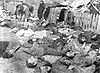
During the wave of massacres of Poles in Volhynia between 1942 and 1945, Dołha Wojniłowska was one of hundreds of sites of mass murder of Polish civilians by OUN-UPA.[2] On April 2, 1944 local Catholic priest, Rev. Błażej Czuba[3] was burned alive in his parish with 85 people. Soon after, on the first night of Easter, April 9-10, 1944, additional 64 people were massacred there during an OUN-UPA murderous raid overlooked by SS-Galizien. The attack was accompanied by the burning and razing of farmhouses, schools and churches.[4]
Sources
- ^ Volhynia Gazetteer. Location according to SGGEE guideline
- ^ (Polish) Stanisław Jastrzębski, Ludobójstwo ludności polskiej przez OUN-UPA w województwie stanisławowskim w latach 1939-1946. Compilation of data from the aforementioned publication including some recorded names of victims from Dołha Wojniłowska prepared by Iwona Łaptaszyńska.
- ^ Kluby Gazety Polskiej, redaktor naczelny Tomasz Sakiewicz, Ze wzgórza pod Krakowem
- ^ Grzegorz Hryciuk, Galicja Wschodnia i Wolyn w latach 1941-1944 Chapter 5. Likwidacja tzw. gett wtórnych. Liczba ofiar Holocaustu w Galicji Wschodniej
- (Polish) GRZEGORZ HRYCIUK, Holocaust in Eastern Galicia 1941-1944
Coordinates: 49°9′19″N 24°22′17″E / 49.15528°N 24.37139°E
Massacres of Polish citizens in World War II Volhynia - Dominopol
- Janowa Dolina
- Kisielin
- Kisorycze
- Kurdybań Warkowicki
- Ostrówki
- Parośla I
- Poryck
- Wola Ostrowiecka
- Żeniówka
Eastern Galicia - Chodaczków Wielki
- Huta Oleska
- Huta Pieniacka
- Korosciatyń
- Lwów
- Palikrowy
- Podkamień
Belarus Lithuania Russia Current Poland  Polish self-defence centres
- Huta Stepańska
- Kuty (in Volhynia)
- Pańska Dolina
- Przebraże
- Stara Huta
Categories:- Polish history stubs
- Ukrainian history stubs
- Villages in Ukraine


Wikimedia Foundation. 2010.