- Dorre Island
-
Dorre Island 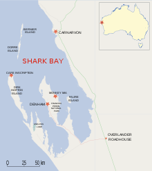
Geography Location Shark Bay Country AustraliaState Western Australia Region Gascoyne Dorre Island is one of three islands that make up the Bernier and Dorre Island Nature Reserve in the Shark Bay World Heritage area in Western Australia.[1] [2] It was, with Bernier Island - a lock hospital location in the early 1900s.[3][4]
Daisy Bates was given name of Kabbarli at Dorre Island.[5]
Contents
Geography
It is located at the north-western corner of the World Heritage area, almost due west of Carnarvon, Western Australia. It is separated from Bernier Island to its south by a 0.5 km gap with a depth of 4 m.
Cape St Cricq is the southern most point, while Cape Boullanger is the northern most point of the Island.
Due to its location south of Bernier, and on the northern side of the opening into Shark Bay where Cape Inscription on Dirk Hartog Island lies to the south, some wrecks and remains have been found.[6]
Fauna
The Banded Hare-wallaby and Rufous Hare-wallaby are both threatened mammal species that were once found on the mainland but are now both restricted to Dorre and Bernier Island. The Rufous Hare-wallaby is being reintroduced to mainland Australia.
See also
References
- ^ Hancock, Sue; Brown, Paul; and Stephens, Burke. (2000). Shark Bay Terrestrial Reserves Management Plan 2000-2009. Department of Conservation and Land Management, for the National Parks and Nature Conservation Authority, Perth, Western Australia. ISBN 0-7307-5510-X
- ^ http://www.ga.gov.au/photos/sg49-8_map9.jpg for a map showing named features of the island
- ^ Hunter, Ernest M. (1993). Aboriginal health and history: power and prejudice in remote Australia. Cambridge [England]; Melbourne: Cambridge University Press. ISBN 0521447607 (History of treating venereal diseases among aborigines in the Kimberley, removal to Dorre and Bernier Islands). Aboriginal health and history, p.58-61.
- ^ Jebb, Mary Anne. (1984). The Lock hospitals experiment: Europeans, aborigines and venereal disease. Studies in Western Australian History, No.8 (Dec. 1984), p.68-87.
- ^ Bates, Daisy (1938). In The passing of the Aborigines : a lifetime spent among the natives of Australia. Murray, London. p.107-114; also as ebook Bates, Daisy (2009). In The Passing of the Aborigines. The University of Adelaide Library, Adelaide - http://ebooks.adelaide.edu.au/b/bates/daisy/passing/
- ^ "WRECKAGE FOUND OFF CARNARVON.". The West Australian (Perth, WA : 1879 - 1954) (Perth, WA: National Library of Australia): p. 8. 21 October 1947. http://nla.gov.au/nla.news-article46808077. Retrieved 26 July 2011.
Coordinates: 24°52′S 113°10′E / 24.867°S 113.167°E
Categories:- Protected areas of Western Australia
- Islands of Western Australia
- Shark Bay
- Western Australia geography stubs

Wikimedia Foundation. 2010.