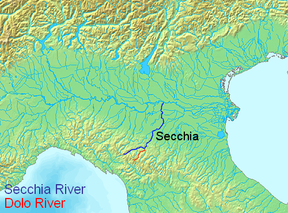
- Dolo River
-
Dolo 
Origin Tuscan-Emilian Apennines, Mount Cusna Mouth Secchia, North of Polinago Basin countries Italy Length 16 mi (26 km) Source elevation approx. 6,129 ft (1,868 m) Avg. discharge unknown Basin area unknown The Dolo mountain stream springs from the Mount Cusna's slopes (44°14′24.21″N 10°27′22.31″E / 44.2400583°N 10.4561972°E), in the Reggio-Emilia province, in the Tuscany-Emilia Romagna Apennine Mountains.
It is a natural boundary for the province of Reggio Emilia and the province of Modena.
Its flow ends into the Secchia river (44°24′24.97″N 10°37′18.80″E / 44.4069361°N 10.621889°E), its length is about 13 to 16 miles (21 to 26 km).
Three miles before ending into the Secchia river the Dragone mountain stream flows into it.
At the height of Fontanaluccia there is a dam (44°16′39.72″N 10°30′47.95″E / 44.2777°N 10.5133194°E) which provides water for a hydroeletric power plant (44°21′42.48″N 10°34′53.35″E / 44.3618°N 10.5814861°E) located 9 miles (14 km) downward in Farneta.
-
Dolo river seen from the bridge crossing to the nearby village of Morsiano
Categories:- Rivers of Italy
- Rivers of Emilia-Romagna
Wikimedia Foundation. 2010.


