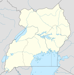
- Dokolo
-
Dokolo Location in Uganda Coordinates: 01°55′07″N 33°10′12″E / 1.91861°N 33.17°E Country  Uganda
Region Northern Uganda Sub-region Lango sub-region District Dokolo District Government - Mayor Elevation 3,543 ft (1,080 m) Population (2011 Estimate) - Total 18,100 Dokolo is a town in Northern Uganda. It is the main municipal, administrative and commercial centre of Dokolo District. The district is named after the town.
Contents
Location
Dokolo is located approximately 58 kilometres (36 mi), by road, southeast of Lira, the largest city in the sub-region.[1] The coordinates of the town are:01 55 07N, 33 10 12E (Latitude:1.9185; Longitude:33.1700). Dokolo lies on the main highway, A-104, between Lira and Soroti.
Population
In 2008, the Uganda Bureau of Statistics (UBOS), estimated the population of the town at 16,200. [2] In 2011, UBOS estimated the mid-year population of Dokolo at 18,100.[3]
Landmarks
The landmarks within the town limits or close to the edges of the town include:
- The headquarters of Dokolo District Administration
- The offices of Dokolo Town Council
- Dokolo Central Market
- A branch of DFCU Bank - One of the licensed commercial banks in in Uganda[4]
See also
- Dokolo District
- Lango sub-region
- Langi people
- Northern Region, Uganda
References
 Dokolo District
Capital: Dokolo Towns and
villagesDokoloEconomy Notable people Cecilia OgwalCategories:- Populated places in Uganda
- Cities in the Great Rift Valley
- Dokolo District
- Northern Region, Uganda
Wikimedia Foundation. 2010.

