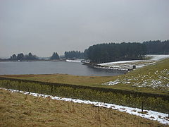
- Dingle Reservoir
-
Dingle Reservoir 
The Dingle Reservoir Location Lancashire, England Coordinates 53°37′38″N 2°27′54″W / 53.62722°N 2.465°WCoordinates: 53°37′38″N 2°27′54″W / 53.62722°N 2.465°W Dingle Reservoir is an artificial, low alkalinity, shallow reservoir near to the town of Egerton, Greater Manchester. The reservoir itself is a little under 400 metres from the border between Lancashire and Greater Manchester, bring found on the Lancashire side.[1][2]
References
- ^ "UK Environment Agency". http://maps.environment-agency.gov.uk/wiyby/wiybyController?topic=wfd_lakes&ep=query&lang=_e&x=371740.0&y=409560.0&scale=4&layerGroups=8&location=Bolton,%20Gr.%20Manchester&textonly=off&latest=true. Retrieved 11 February 2010.
- ^ "Google Earth". http://maps.google.co.uk/maps?f=q&source=s_q&hl=en&q=Dingle+Reservoir,+Belmont,+Blackburn+with+Darwen+BL7,+United+Kingdom&sll=53.800651,-4.064941&sspn=14.171015,39.506836&ie=UTF8&hq=&hnear=Dingle+Reservoir&t=h&cd=1&geocode=FVFJMgMdaV_a_w&split=0&ll=53.625248,-2.45244&spn=0.027742,0.077162&z=14. Retrieved 11 February 2010.
Categories:- Lancashire geography stubs
- Buildings and structures in Blackburn with Darwen
- Drinking water reservoirs in England
Wikimedia Foundation. 2010.
