- De Weere, Niedorp
-
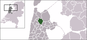
De Weere — Town — 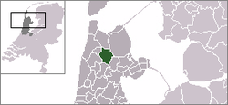 De Weere in the municipality of Niedorp.
Coordinates: 52°46′28″N 4°52′1″E / 52.77444°N 4.86694°ECoordinates: 52°46′28″N 4°52′1″E / 52.77444°N 4.86694°E Country Netherlands Province Noord-Holland Municipality Niedorp Population – Total 70 Time zone CET (UTC+1) – Summer (DST) CEST (UTC+2) Postal code De Weere (West Frisian: De Weare) is a town in the Dutch province of North Holland. It is a part of the municipality of Niedorp, and lies about 12 km north of Heerhugowaard.
The statistical area "De Weere", which also can include the surrounding countryside, has a population of around 110.[1]
References
- ^ Statistics Netherlands (CBS), Statline: Kerncijfers wijken en buurten 2003-2005. As of 1 January 2005.
Categories:- Populated places in North Holland
- North Holland geography stubs

Wikimedia Foundation. 2010.