Darkhad Valley

Darkhad Valley
DarhadynHotgor2.JPG

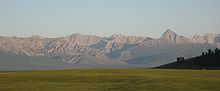
The Darkhad valley (Mongolian: Дархадын хотгор) is a large valley in northwestern Khövsgöl aimag, Mongolia. It is situated between the Ulaan Taiga and Khoridol Saridag ranges at an altitude of about 1600 m, about 160 km long and 40 km wide. The area is 4270 km². It was transferred from the People's Republic of Tannu Tuva to the Mongolian People's Republic in 1925 as a Soviet concession to the Mongolians, who had wanted to incorporate the territory of Tannu Uriankhai into their country.[1][2]

The valley is rich in lakes and rivers, the biggest of which are Dood Tsagaan Lake and Shishged River, respectively. The area is famous for its natural beauty, but relatively remote and inaccessible even by Mongolian standards.

The Darkhad valley is divided between the Ulaan-Uul, Renchinlkhümbe, and Tsagaannuur sums. Inhabitants are mainly Darkhad (whom the valley's name derives from), and also some Tsaatan.

Coordinates: 51°10′N 99°30′E / 51.167°N 99.5°E / 51.167; 99.5

References

  1. ^ Denis Sinor. The Uralic and Altaic Series Volume 126. Richmond: Curzon Press Ltd., 1997. pp. 7-8.
  2. ^ Peter S. H. Tang. Russian and Soviet Policy in Manchuria and Outer Mongolia, 1911-1931. London: Duke University Press., 1959. p. 417.

Wikimedia Foundation. 2010.

Игры ⚽ Нужно решить контрольную?

Look at other dictionaries:

  • Darkhad valley — ranges at an altitude of about 1600 m, about 160 km long and 40 km wide. The area is 4270 km².The valley is rich in lakes and rivers, the biggest of which are Dood Tsagaan nuur and Shishged gol, respectively. The area is famous for its natural… …   Wikipedia

  • Darkhad — Total population 21,558 Regions with significant populations  Mongolia …   Wikipedia

  • Tsagaannuur, Khövsgöl — NOTOC Tsagaannuur ( mn. Цагааннуур = white lake ) is a sum of Khövsgöl aimag. The area is 5,410 km². In 2000, Tsagaannuur had a population of 1,317 people, of which most identified themselves as Darkhad. 269 inhabitants identified themselves as… …   Wikipedia

  • Renchinlkhümbe, Khövsgöl — NOTOC Renchinlkhümbe ( mn. Рэнчинлхүмбэ) is a sum of Khövsgöl aimag. The area is about 8,850 km², of which 2,910 km² are pasture and 35 % are forest. In 2000, the sum had 4284 inhabitants, mainly Darkhad. The sum center, officially named Zöölön ( …   Wikipedia

  • Ulaan-Uul, Khövsgöl — NOTOC Ulaan Uul ( mn. Улаан Уул = red mountain ) is a sum of Khövsgöl aimag. The area is close to 10,000 km². In 2000, Ulaan Uul had a population of 3,726 people, mainly Darkhad. The sum center, officially named Tögöl ( mn. Төгөл ), is located… …   Wikipedia

  • Dood Tsagaan nuur — Infobox lake lake name = Dood Tsagaan nuur image lake = caption lake = image bathymetry = caption bathymetry = location = Darkhad Valley coords = coord|51|19|N|99|23|E|type:waterbody region:MN|display=inline,title type = inflow = Shishged Gol,… …   Wikipedia

  • Shishged Gol — Geobox|River name = Shishged Gol native name = mn. Шишгэд гол other name = Shishged River category = etymology = nickname = image caption = country = Mongolia country1 = Russia state type = Aimag state = Khövsgöl state1 = region = district =… …   Wikipedia

  • Río Yeniséi — «Yeniséi» redirige aquí. Para otras acepciones, véase Yeniséi (desambiguación). Río Yeniséi (Енисей) Vista del río a su paso por Krasnoyarsk …   Wikipedia Español

  • Dood Tsagaan Lake — Location Darkhad Valley Coordinates 51°19′N 99°23′E …   Wikipedia

  • Khalka Mongols — For a river, see Khalkha River. Khalkha Regions with significant populations  Mongolia 2,168,141 …   Wikipedia

Share the article and excerpts

Direct link
Do a right-click on the link above
and select “Copy Link”