Cottonwood Mountains (Lassen County)
- Cottonwood Mountains (Lassen County)
-
The Cottonwood Mountains are a mountain range in eastern Lassen County, California, near Nevada.[1]
References
Categories:
- Mountain ranges of Lassen County, California
- Mountain ranges of Northern California
- Lassen County, California geography stubs
Wikimedia Foundation.
2010.
Look at other dictionaries:
Cottonwood Mountains — may refer to: Cottonwood Mountains (Inyo County), California, USA Cottonwood Mountains (Lassen County), California, USA Cottonwood Mountains (Riverside County), California, USA This set index article includes a list of mountains that share the… … Wikipedia
Lassen Volcanic National Park — IUCN Category II (National Park) … Wikipedia
Shasta County, California — County of Shasta County Seal … Wikipedia
List of California county name etymologies — This is a list of California county name etymologies. Most of California s counties were named by Spanish explorers, often for a Roman Catholic saint whose feast day intersected with the advance into a new part of Alta California. Native American … Wikipedia
Coxcomb Mountains — Coordinates: 33°56′12.047″N 115°20′30.936″W / 33.93667972°N 115.34192667°W / 33.93667972; 115.34192667 … Wikipedia
Newberry Mountains (California) — For the mountains with the same name in Nevada see Newberry Mountains (Nevada). Coordinates: 34°46′29.963″N 116°43′33.114″W / … Wikipedia
Chuckwalla Mountains — Coordinates: 33°35′30.084″N 115°22′32.937″W / 33.59169°N 115.37581583°W / 33.59169; 115.37581583 … Wikipedia
Chemehuevi Mountains — Coordinates: 34°37′30.031″N 114°31′32.863″W / 34.62500861°N 114.52579528°W / 34.62500861; 114.52579528 … Wikipedia
Orocopia Mountains — Coordinates: 33°34′0.086″N 115°46′32.974″W / 33.56669056°N 115.77582611°W / 33.56669056; 115.77582611 … Wikipedia
Old Woman Mountains Wilderness — IUCN Category Ib (Wilderness Area) … Wikipedia
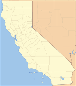
 location of Cottonwood Mountains in California [1]