- Coppermine Peninsula
-
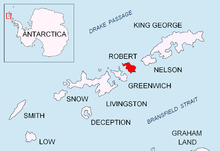
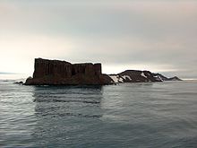
Coppermine Peninsula is the 1.7 km long, 500 m wide and rising to 105 m rugged rocky promontory forming the northwest extremity of Alfatar Peninsula and Robert Island in the South Shetland Islands, Antarctica and lying between English Strait to the west and Carlota Cove to the east. It is linked to Alfatar Peninsula to the southeast by a narrow isthmus bounded by Carlota Cove to the north and the 1 km wide and 460 m indenting Coppermine Cove (62°22′54″S 59°41′53″W / 62.38167°S 59.69806°W) to the south. Coppermine Peninsula has a regime of special environmental protection under the Antarctic Treaty System.
The feature is named in association with the adjacent Coppermine Cove, a descriptive name given by sealers in about 1821 from the copper-coloured staining of the lavas and tuffs in the area.
Contents
Location
The peninsula is centred at 62°22′27.2″S 59°42′46.4″W / 62.374222°S 59.712889°W (British mapping in 1822 and 1968, Chilean in 1971, Argentine in 1980, and Bulgarian in 2009).
See also
Maps
- Chart of South Shetland including Coronation Island, &c. from the exploration of the sloop Dove in the years 1821 and 1822 by George Powell Commander of the same. Scale ca. 1:200000. London: Laurie, 1822.
- L.L. Ivanov. Antarctica: Livingston Island and Greenwich, Robert, Snow and Smith Islands. Scale 1:120000 topographic map. Troyan: Manfred Wörner Foundation, 2009. ISBN 978-954-92032-6-4
References
- SCAR Composite Antarctic Gazetteer.
- Management Plan for Specially Protected Area No. 16 Coppermine Peninsula. Secretariat of the Antarctic Treaty.
- ASPA 112: Coppermine Peninsula, Robert Island, South Shetland Islands. Secretariat of the Antarctic Treaty.

This South Shetland Islands location article is a stub. You can help Wikipedia by expanding it.


