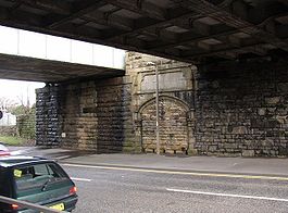
- Cooper Bridge railway station
-
Cooper Bridge 
Blocked entrance to former railway station, Cooper Bridge Road. Location Place Mirfield Area Kirklees Coordinates 53°41′06″N 1°43′55″W / 53.68487°N 1.732°WCoordinates: 53°41′06″N 1°43′55″W / 53.68487°N 1.732°W Grid reference SE177209 Operations Original company Manchester and Leeds Railway Pre-grouping Lancashire and Yorkshire Railway Post-grouping London, Midland and Scottish Railway Platforms 2 History 1 October 1840 Station opens 20 February 1950 Station closes Disused railway stations in the United Kingdom Closed railway stations in Britain
A B C D–F G H–J K–L M–O P–R S T–V W–ZCooper Bridge was a railway station built by the Manchester and Leeds Railway to serve the town of Huddersfield in West Yorkshire, England.[1]
History
Opened by the Manchester and Leeds Railway in 1840 to serve Huddersfield, 4 miles (6.4 km) away, which at that time did not have a station of its own.[2] The station was said to have been built for and by, the owner of Kirklees Hall the Armytage family.[3][4]
References
- ^ Butt, R. V. J. (1995). The Directory of Railway Stations: details every public and private passenger station, halt, platform and stopping place, past and present (1st ed.). Sparkford: Patrick Stephens Ltd. ISBN 1-8526-0508-1. OCLC 60251199.
- ^ Anderson, Robert (2000). Huddersfield Dewsbury and Batley (Railway Memories). Bellcode Books. ISBN 1-8712-3313-5.
- ^ Calderdale Companion - Cooper Bridge station
- ^ Malcolm Bull's Calderdale Companion - Photo of station platform
External links
Preceding station Historical railways Following station Clifton Road Lancashire and Yorkshire Railway
Pickle Bridge LineMirfield Brighouse Lancashire and Yorkshire Railway
Caldervale LineCategories:- Disused railway stations in Kirklees
- Former Lancashire and Yorkshire Railway stations
- Railway stations opened in 1840
- Railway stations closed in 1950
- Yorkshire and the Humber railway station stubs
Wikimedia Foundation. 2010.
