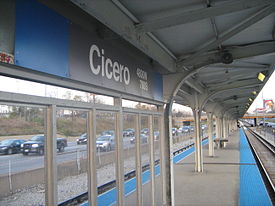
- Cicero (CTA Blue Line station)
-
For other 'L' stations on the Chicago Transit Authority named Cicero, see Cicero (CTA station).
Cicero 
Station statistics Address 720 South Cicero Avenue
Chicago, Illinois 60644Coordinates 41°52′18″N 87°44′43″W / 41.871574°N 87.745154°WCoordinates: 41°52′18″N 87°44′43″W / 41.871574°N 87.745154°W Lines Structure Surface Level Platforms 1 island platform Tracks 2 Other information Opened June 22, 1958 Owned by Chicago Transit Authority Traffic Passengers (2008) 378,519  3.2% (CTA)
Services Preceding station Chicago 'L' Following station Pulaskitoward O'HareBlue Line Austintoward Forest ParkCicero is a station on the 'L' system, serving the Blue Line's Forest Park branch. It is the westernmost station situated in the median of the Eisenhower Expressway. Originally Cicero had an additional entrance at Lavergne Avenue, but this was closed on May 16, 1977, by the CTA as a cost cutting measure. The structure for this exit still stands but it is closed to the public.
Bus connections
- #7 Harrison
- #54 Cicero
- #57 Laramie
External links
- Cicero (Congress Line) Station Page
- LaVergne Avenue entrance (closed) from Google Maps Street View
- Cicero Avenue entrance from Google Maps Street View
Categories:- CTA Blue Line stations
- Railway stations opened in 1958
- Chicago Transit Authority stubs
- Illinois railway station stubs
Wikimedia Foundation. 2010.
