- Church of St Mary, Stogumber
-
Church of St Mary 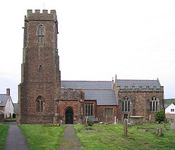
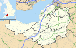
 Location within Somerset
General information Town or city Stogumber Country England Coordinates 51°07′40″N 3°17′25″W / 51.1278°N 3.2903°W Completed late 13th century The Church of St Mary in Stogumber, Somerset, England dates from the late 13th century. It has been designated as a Grade I listed building.[1]
The church was founded as a Saxon minster with a chapelry at Bicknoller and other dues payable from property in Monksilver, Clatworthy and Elworthy.[2]
The oldest portions of the church are the tower and south porch. The north aisle is traditionally held to have been built by Cardinal Beaufort as a penance for his behaviour at his hunting lodge Halsway Manor.[3] The red sandstone church was restored in the 1870s to designs by John Dando Sedding.[4] The interior includes a chandelier built around 1770. The font is from the 15th century. The church has a stone pulpit.[5]
The Old Vicarage, which is now a private dwelling, was built in the 15th century.[6] The old brewhouse behind the vicarage is medieval in origin.[7]
The parish is part of the Quantock Towers benefice within the Quantock deanery.[4]
See also
- List of Grade I listed buildings in West Somerset
- List of towers in Somerset
References
- ^ "Church of St Mary". Images of England. English Heritage. http://www.imagesofengland.org.uk/Details/Default.aspx?id=264926. Retrieved 6 February 2009.
- ^ Bush, Robin (1994). Somerset: The Complete Guide. Dovecote Press. pp. 193–194. ISBN 1874336261.
- ^ "Stogumber". Quantock Online. http://www.quantockonline.co.uk/quantocks/villages/stogumber/stogumber01.html. Retrieved 6 November 2011.
- ^ a b "The Blessed Virgin Mary, Stogumber". Church of England. http://www.achurchnearyou.com/stogumber-the-blessed-virgin-mary/. Retrieved 6 November 2011.
- ^ "St Mary's church". Stogumber. http://www.stogumber.org.uk/church.php. Retrieved 6 November 2011.
- ^ "The Old Vicarage". Images of England. English Heritage. http://www.imagesofengland.org.uk/Details/Default.aspx?id=264930. Retrieved 6 February 2009.
- ^ "The Brewhouse, about 10 metres South of The Old Vicarage". Images of England. English Heritage. http://www.imagesofengland.org.uk/Details/Default.aspx?id=264931. Retrieved 6 February 2009.
Categories:- Church of England churches in Somerset
- 13th-century architecture
- Grade I listed churches
- Grade I listed buildings in Somerset
- West Somerset


Wikimedia Foundation. 2010.