Church of St Martin, North Perrott

Church of St Martin, North Perrott
Church of St Martin
Stone building with square tower.
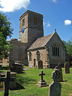
Location: North Perrott, Somerset, England
Coordinates: 50°52′57″N 2°45′0″W / 50.8825°N 2.75°W / 50.8825; -2.75Coordinates: 50°52′57″N 2°45′0″W / 50.8825°N 2.75°W / 50.8825; -2.75
Built: 12th century
Listed Building – Grade I
Designated: 19 April 1961[1]
Reference #: 262429
Church of St Martin, North Perrott is located in Somerset
{{{alt}}}
Location of Church of St Martin in Somerset

The Church of St Martin in North Perrott, Somerset, England dates from the 12th century and has been designated as a Grade I listed building.[1]

The current church which is near the River Parrett, was built on the site of an earlier church and including some of the fabric, in the 16th century, probably by Henry Daubney, 1st Earl of Bridgewater.[2]

The tower dates from the 12th century and contains six bells. The oldest was cast in 1786 by George Davis of Bridgwater. Four others were made by members of the Bilbie family in 1803.[2]

The parish is part of the Wulfric benefice within the Crewkerne and Ilminster deanery.[3]

See also

References

  1. ^ a b "Church of St Martin". Images of England. English Heritage. http://www.imagesofengland.org.uk/Details/Default.aspx?id=262429. Retrieved 7 June 2009. 
  2. ^ a b "History". North Perrott Church. http://www.northperrottchurch.co.uk/history.htm. Retrieved 30 October 2011. 
  3. ^ "St Martin, North Perrott". Church of England. http://www.achurchnearyou.com/north-perrott-st-martin/. Retrieved 30 October 2011. 

Wikimedia Foundation. 2010.

Игры ⚽ Поможем написать реферат

Look at other dictionaries:

  • North Perrott — Coordinates: 50°52′57″N 2°44′51″W / 50.8825°N 2.7476°W / 50.8825; 2.7476 …   Wikipedia

  • North Leigh — There is also a Northleigh in Devon. Coordinates: 51°48′47″N 1°26′24″W / 51.813°N 1.440°W / 51.813; 1.440 …   Wikipedia

  • List of Grade I listed buildings in Somerset — There are over 6000 Grade I listed buildings in England. This page is a list of these buildings in the county of Somerset.Bath North East Somerset* Abbey Church, Bath (Grade A) * Abbey Church Yard, Bath: No 14 * Grand Pump Room, Bath * Grand Pump …   Wikipedia

  • Timeline of Birmingham history — This article is intended to show a timeline of events in the History of Birmingham, England, with a particular focus on the events, people or places that are covered in Wikipedia articles.Pre Norman invasion* 1200 BC: Radiocarbon date of charcoal …   Wikipedia

  • Chard, Somerset — Coordinates: 50°52′22″N 2°57′31″W / 50.8728°N 2.9587°W / 50.8728; 2.9587 …   Wikipedia

  • List of Grade I listed buildings in Dorset — There are over 6000 Grade I listed buildings in England. This page is a list of these buildings in the county of Dorset, sub divided by district.Christchurch* Waterloo Bridge, Christchurch * Christchurch Castle * The Constable s House,… …   Wikipedia

  • Cricket St Thomas — Coordinates: 50°52′19″N 2°53′42″W / 50.872°N 2.895°W / 50.872; 2.895 …   Wikipedia

  • Templecombe — Coordinates: 51°00′00″N 2°24′54″W / 50.999982°N 2.415075°W / 50.999982; 2.415075 …   Wikipedia

  • Birmingham — This article is about the city in England. For the U.S. city named after it, see Birmingham, Alabama. For other uses, see Birmingham (disambiguation). City of Birmingham   City and Metropolitan borough   …   Wikipedia

  • Durrus and District History Modern — Durrus is an area of West Cork in Ireland. For earlier history, see Durrus and District History1900 2000 James Gilhooley M.P. and Elections 1910James Gilhooley MP (he had been a merchant in Bantry, and was jailed on a number of occaasions under… …   Wikipedia

Share the article and excerpts

Direct link
Do a right-click on the link above
and select “Copy Link”