Church Road Garston railway station
- Church Road Garston railway station
-
Church Road Garston railway station is a disused station Garston in England, it was situated on the west side of Church Road.
History
The station opened in 1 March 1881 and closed 3 July 1939.[1]
| Preceding station |
Disused railways |
Following station |
| Garston Dock |
|
LNWR
St Helens Railway |
|
Speke |
LNWR
St Helens Railway |
Allerton |
References
Categories:
- Disused railway stations in Liverpool
- Railway stations opened in 1881
- Railway stations closed in 1939
- Merseyside railway station stubs
Wikimedia Foundation.
2010.
Look at other dictionaries:
Church Road — is a very common location in the United Kingdom. The following are known to Wikipedia: Church Road (Birmingham); former Midland Railway station, closed in 1925 Church Road (Garston); former L NWR station, closed in 1939 Church Road (Harlesden);… … Wikipedia
Moorfields railway station — Moorfields Platform 1 at Moorfields station Loca … Wikipedia
Church of St Luke, Liverpool — Church of St Luke St Luke s General information Town or city Liverpool … Wikipedia
Garston, Merseyside — infobox UK place country = England official name= Garston latitude= 53.3518 longitude= 2.894 population= metropolitan borough= City of Liverpool metropolitan county= Merseyside region= North West England constituency westminster= post town=… … Wikipedia
Church of Our Lady and Saint Nicholas, Liverpool — St Nick s The Church of Our Lady and Saint Nicholas is known locally as The Sailors Church and simply St Nick s . General information Town or city Liverpool … Wikipedia
Garston, Hertfordshire — infobox UK place country = England latitude= 51.6894 longitude= 0.3845 official name= Garston population = 20 417 (ONS Census 2001) shire district=Watford shire county = Hertfordshire region= East of England constituency westminster= Watford post … Wikipedia
Listed buildings in Liverpool — Partial and incomplete lists of listed buildings in Liverpool, England. A *July 28 1952 II Abercromby Square L7 Garden House *July 28 1952 II Abercromby Square (west side) L7 Nos. 1 to 7 (consec) No. 7a *July 28 1952 II Abercromby Square (south… … Wikipedia
Liverpool — This article is about the city. For the football club, see Liverpool F.C.. For other uses, see Liverpool (disambiguation). Liverpool Metropolitan borough … Wikipedia
Mossley Hill — Coordinates: 53°22′44″N 2°55′05″W / 53.379°N 2.918°W / 53.379; 2.918 … Wikipedia
Kingston upon Hull — City of Kingston upon Hull City and Unitary Authority area The Queen s Gardens, Maritime Museum, and City Hall (rear) in Kingston upon Hull … Wikipedia
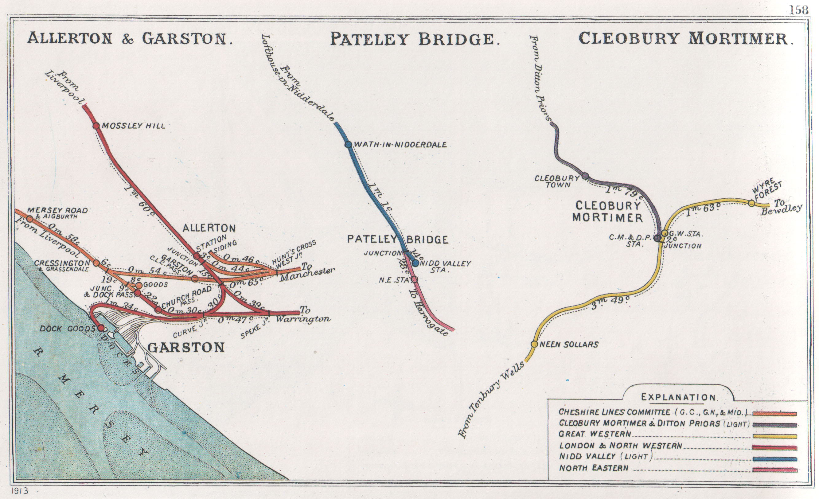
 A 1913 Railway Clearing House map (left) of railways in the vicinity of Church Road Garston