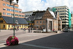
Christiania torv (station)
Look at other dictionaries:
Nationaltheatret (station) — For the mainline railway station underneath, see Nationaltheatret Station. Nationaltheatret Entrance Location Place Vika Municipality … Wikipedia
Oslo Hospital (station) — Oslo Hospital Location Place Gamlebyen Coordinates 59°54′12″N … Wikipedia
Merradalen (station) — Merradalen Location Place Ullern Municipality Aker (1935–1948) Oslo (1948–) Line Kolsås Line Distance 5.1 km (3.2 mi) Elevation 82.0 m (269.0 ft) … Wikipedia
Olaf Ryes plass — Map of the district, 1917. Olaf Ryes plass is the green, centrally placed square. Olaf Ryes plass (lit. Olaf Rye s Square ) is a square and park placed centrally in the Grünerløkka borough of Oslo, Norway. It is more or less quadratic in shape.… … Wikipedia
Østensjø Line — MX3000 train near Ulsrud Overview Type Rapid transit System … Wikipedia
Oslo Sporveier — AS Oslo Sporveier Former type Municipally owned Industry Public transport Fate Demerger … Wikipedia
Oslo Tramway — Info Owner Kollektivtransportproduksjon Locale Oslo, Norway … Wikipedia
Oslo Package 3 — is a political agreement and plan for investments of NOK 53 billion in Oslo and Akershus, Norway. It involves financing for road and public transport infrastructure, as well as operating subsidies to public transport in the period 2008–27.… … Wikipedia
Oslo Tramway Museum — The museum at Majorstuen Heritage tram no. 70 … Wikipedia
Christianshavn — The Church of Our Saviour (Vor Frelser Kirke) in the Christianshavn city district, Copenhagen, Denmark. Photo: Niels Elgaard Larsen, 2005. Christianshavn is an artificial island neighbourhood located in Copenhagen, Denmark. It was founded in the… … Wikipedia

