Bumthang Valley

Bumthang Valley
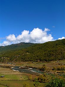
View of Bumthang valley.

Bumthang Valley, or Choekhor Valley is the main inhabited valley in the Bumthang district of Bhutan.

The main town in the valley is Jakar. Bhutan's only brewery, brewing Red Panda wheat beer, is in Jakar.

Coordinates: 27°33′N 90°45′E / 27.55°N 90.75°E / 27.55; 90.75


Wikimedia Foundation. 2010.

Игры ⚽ Поможем решить контрольную работу

Look at other dictionaries:

  • Bumthang District — Bumthang is one of the 20 dzongkhag (districts) comprising Bhutan. It is the most historic dzongkhag if the number of ancient temples and sacred sites is counted. Bumthang consists of the four mountain valleys of Ura, Chumey, Tang and Choekhor… …   Wikipedia

  • Bumthang — may refer to: * Bumthang (town) * Bumthang District * Bumthang River * Bumthang Valley * Bumthang language …   Wikipedia

  • Bumthang (town) — Infobox Settlement official name = Tang other name = native name = Tang nickname = settlement type = Valley motto = imagesize = image caption = Archery field in Bumthang flag size = image seal size = image shield = shield size = image blank… …   Wikipedia

  • Trongsa Dzong — Chhoekhor Raptentse Dzong Choetse Dzong Trongsa Dzong …   Wikipedia

  • Jakar — Infobox Settlement official name = PAGENAME other name = native name = nickname = settlement type = motto = imagesize = 240px image caption = Houses in the Bumthang valley near the village of Jakar flag size = image seal size = image shield =… …   Wikipedia

  • Choekhor — Valley (also known as Bumthang Valley) is the main inhabitedvalley in the Bumthang district of Bhutan.The main village in the valley is Jakar.Bhutan s only brewery, brewing Red Panda wheat beer, is in Jakar …   Wikipedia

  • Kurjey Lhakhang — Kurjey Lhakang, also known as Kurjey Monastery, is located in the Bumthang valley in the Bumthang district of Bhutan. This is the final resting place of the remains of the first three kings of Bhutan. As well, a large tree behind one of the… …   Wikipedia

  • Tsechu — (literally day ten ) are annual religious Bhutanese festivals held in each district or dzongkhag of Bhutan on the tenth day of a month of the lunar Tibetan calendar. The month depends on the place, but usually is around the time of October.… …   Wikipedia

  • Bhutan — Coordinates: 27°25′01″N 90°26′06″E /  …   Wikipedia

  • Tang Chuu — Mouth Mo Chhu Basin countries Bhutan River system Mo Chhu Left tributaries Yenyer Chhu …   Wikipedia

Share the article and excerpts

Direct link
Do a right-click on the link above
and select “Copy Link”