Numansdorp

Numansdorp
Numansdorp
Coordinates: 51°43′59″N 4°26′17″E / 51.73306°N 4.43806°E / 51.73306; 4.43806
Country Netherlands
Province Zuid-Holland
Municipality Cromstrijen
Population (2007) 9,010
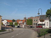
Numansdorp, view to the village

Numansdorp is a village in the Municipal Cromstrijen in the province South Holland in the Netherlands.

On the 31st December 2004 Numansdorp had 9910 residents (4414 men and 4496 women) according to the municipal website (http://www.cromstrijen.nl/).

Coordinates: 51°44′N 4°26′E / 51.733°N 4.433°E / 51.733; 4.433


Wikimedia Foundation. 2010.

Игры ⚽ Поможем решить контрольную работу

Look at other dictionaries:

  • Numansdorp — 51°43′59″N 4°26′17″E / 51.73306, 4.43806 …   Wikipédia en Français

  • Numansdorp — Gemeinde Cromstrijen Flagge Wappen Provinz Südholland …   Deutsch Wikipedia

  • Numansdorp — Sp Niùmansdorpas Ap Numansdorp L Nyderlandai …   Pasaulio vietovardžiai. Internetinė duomenų bazė

  • Hochwasserkatastrophe von 1953 — Blick über das überflutete Oude Tonge Goeree Overflakkee Die Flutkatastrophe von 1953 (in den Niederlanden und Flandern als Watersnood oder kurz de Ramp (die Katastrophe), in Großbritannien als (Great) North Sea flood oder East Coast floods und… …   Deutsch Wikipedia

  • Hollandflut — Blick über das überflutete Oude Tonge Goeree Overflakkee Die Flutkatastrophe von 1953 (in den Niederlanden und Flandern als Watersnood oder kurz de Ramp (die Katastrophe), in Großbritannien als (Great) North Sea flood oder East Coast floods und… …   Deutsch Wikipedia

  • Hollandsturmflut — Blick über das überflutete Oude Tonge Goeree Overflakkee Die Flutkatastrophe von 1953 (in den Niederlanden und Flandern als Watersnood oder kurz de Ramp (die Katastrophe), in Großbritannien als (Great) North Sea flood oder East Coast floods und… …   Deutsch Wikipedia

  • Cromstrijen — Gemeinde Cromstrijen Flagge Wappen Provinz Südholland Bürgermeiste …   Deutsch Wikipedia

  • Flutkatastrophe von 1953 — Blick über das überflutete Oude Tonge auf Goeree Overflakkee Die Flutkatastrophe von 1953 (in den Niederlanden und Flandern als Watersnood oder kurz de Ramp (die Katastrophe), in Großbritannien als (Great) North Sea flood oder East Coast floods… …   Deutsch Wikipedia

  • Liste der ehemaligen Gemeinden in Südholland — Hierunter folgt eine Liste der ehemaligen südholländischen Gemeinden. Wenn das Gebiet einer aufgehobenen Gemeinde über mehrere Gemeinden verteilt worden ist, ist das Großteil der erstgenannten Gemeinde hinzugefügt. Grenzkorrekturen zwischen… …   Deutsch Wikipedia

  • Rijksweg 4 — Vorlage:Infobox hochrangige Straße/Wartung/NL A Autosnelweg A4 in den Niederlanden …   Deutsch Wikipedia

Share the article and excerpts

Direct link
Do a right-click on the link above
and select “Copy Link”