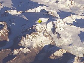
Cerro Steffen

Cerro Steffen
Cerro Steffen

Cerro Steffen indicated by an arrow.
Elevation 3,056 m (10,026 ft) [1]
Location
Location Chile
Range Andes
Coordinates 48°33′03″S 73°08′56″W / 48.55083°S 73.14889°W / -48.55083; -73.14889
Climbing
First ascent 1965 by Pedro and Jorge Skvarca [2]

Cerro Steffen is one of the highest mountains in the Southern Patagonian Ice Field. It lies on the northeastern edge of the just mentioned icefield, west of O'Higgins Lake.

References


Wikimedia Foundation. 2010.

Игры ⚽ Нужна курсовая?

Look at other dictionaries:

  • Cerro Steffen — Para el lago del mismo nombre, véase Lago Steffen. Cerro Steffen Tipo Montaña País &# …   Wikipedia Español

  • Cerro Steffen — Sp Stèfeno kálnas Ap Cerro Steffen L Patagonijos Anduose, Argentina (Čubutas) ir P Čilė …   Pasaulio vietovardžiai. Internetinė duomenų bazė

  • Cerro El Cóndor — El Condor from the south Elevation 6,532 m (21,430 ft) …   Wikipedia

  • Stefeno kalnas — Sp Stèfeno kálnas Ap Cerro Steffen L Patagonijos Anduose, Argentina (Čubutas) ir P Čilė …   Pasaulio vietovardžiai. Internetinė duomenų bazė

  • Disputa limítrofe del río Encuentro-Alto Palena — Saltar a navegación, búsqueda La disputa limítrofe entre la República Argentina y la República de Chile por el trazado del límite entre los hitos XVI y XVII de su frontera común en los valles situados al norte del lago General Vintter/Palena… …   Wikipedia Español

  • CL-AI — Aysén (Region XI) Regionen Chiles …   Deutsch Wikipedia

  • Región de Aisén — Aysén (Region XI) Regionen Chiles …   Deutsch Wikipedia

  • Parque Nacional Nahuel Huapi — Saltar a navegación, búsqueda Nahuel Huapi Categoría IUCN II (Parque nacional) …   Wikipedia Español

  • March 2010 in sports — << March 2010 >> S M T W T F …   Wikipedia

  • Río Cisnes — (‚Schwanenfluss‘) Vorlage:Infobox Fluss/KARTE fehlt Daten …   Deutsch Wikipedia

Share the article and excerpts

Direct link
Do a right-click on the link above
and select “Copy Link”