- Cerro Ejido
-
Cerro Ejido — Suburb of Artigas — Location in Uruguay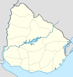
 Cerro Ejido
Coordinates: 30°26′S 56°27′W / 30.433°S 56.45°WCoordinates: 30°26′S 56°27′W / 30.433°S 56.45°W Country  Uruguay
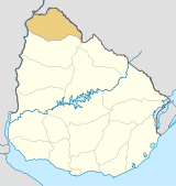
Department Artigas Department Population (2004) - Total 516 Time zone UTC -3 Postal code 55000 Area code(s) +598 477 Cerro Ejido is a suburb of the city of Artigas in the Artigas Department of northern Uruguay. It is located at the south urban limits of the city. The populated fragments of San Eugenio and Cerro Signorelli lie to its west and the suburb Pintadito lies to its south. Route 30 passes a small distance to the east of these suburbs.
Population
In 2004, it had a population of 516 inhabitants.[1]
Year Population 1996 177 2004 516 Source: Instituto Nacional de Estadística de Uruguay[2]
References
- ^ "2004 Census of Artigas department" (XLS). INE. 2004. http://www.ine.gub.uy/fase1new/Artigas/Cuadro7_02.XLS. Retrieved 4 July 2011.
- ^ "1963–1996 Statistics / L" (DOC). Instituto Nacional de Estadística de Uruguay. 2004. http://www.ine.gub.uy/biblioteca/toponimico/TOPOletraL.doc. Retrieved 3 July 2011.
External links
 Artigas Department of Uruguay
Capital: Artigas Towns and
villagesArtigas • Baltasar Brum • Bella Unión • Bernabé Rivera • Cainsa • Cerro Ejido • Colonia Palma • Coronado • Cuareim • Franquia • Las Piedras • Mones Quintela • Pintadito • Sequeira • Tomás Gomensoro
Sights Categories:- Uruguay geography stubs
- Populated places in the Artigas Department


Wikimedia Foundation. 2010.