Otemma Glacier

Otemma Glacier
Glacier d'Otemma
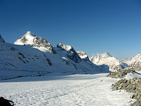
Location Valais, Switzerland
Coordinates 45°57′23″N 7°27′26″E / 45.95639°N 7.45722°E / 45.95639; 7.45722Coordinates: 45°57′23″N 7°27′26″E / 45.95639°N 7.45722°E / 45.95639; 7.45722
Length 7.7 km

The Otemma Glacier (French: Glacier d'Otemma) is a 7.7 km (4.8 mi) long glacier (2005) situated in the Pennine Alps in the canton of Valais in Switzerland. In 1973 it had an area of 17.5 km2 (6.8 sq mi).

See also

External links


Wikimedia Foundation. 2010.

Игры ⚽ Нужен реферат?

Look at other dictionaries:

  • Glacier d'Otemma — Vue de la partie médiane du glacier d Otemma. Latitude Longitude …   Wikipédia en Français

  • Glacier d'Arolla — Vue du glacier d Arolla. Latitude Longitude …   Wikipédia en Français

  • Glacier d'Otemma — Otemmagletscher Der Otemmagletscher (französisch Glacier d’Otemma; teilweise auch Hautemmagletscher genannt) ist ein Talgletscher in den südlichen Walliser Alpen, in der Schweiz. Heute hat der Gletscher eine Länge von rund 8 km und eine… …   Deutsch Wikipedia

  • Haute Route — The Haute Route, (or The High Route or Mountaineers Route) is the name given to a route (with several variations) undertaken on foot or by ski touring between Chamonix, France and Zermatt, Switzerland.First charted as a summer mountaineering… …   Wikipedia

  • Dranse d'Entremont — Die Dranse in Martigny Dranse de Bagnes …   Deutsch Wikipedia

  • Dranse de Bagnes — Die Dranse in Martigny Dranse de Bagnes …   Deutsch Wikipedia

  • Dranse de Ferret — Die Dranse in Martigny Dranse de Bagnes …   Deutsch Wikipedia

  • Staumauer Mauvoisin — Lac de Mauvoisin Blick von der Staumauer auf den See Daten Lage: Wallis …   Deutsch Wikipedia

  • Canton Du Valais — Kanton Wallis …   Wikipédia en Français

  • Canton de Valais — Canton du Valais Canton du Valais Kanton Wallis …   Wikipédia en Français

Share the article and excerpts

Direct link
Do a right-click on the link above
and select “Copy Link”