- Masahuat
-
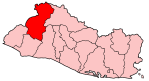
Masahuat is a municipality in the Santa Ana department of El Salvador.
Masahuat is a small town in the State of Santa Ana. El Salvador's main river, Lempa runs near it. Up until a few years ago Lempa's current would be so strong that the town was inaccessible by vehicle during the rainy winter months.
Residents would have to cross the river over hanging man bridges. A few years ago a bridge was built and the town is now accessible by vehicle year round. The bridge also provides access to Cerro Los Flores and other small towns nearby.
Residents are mostly farmers, with corn and beans being the crop of choice. Cattle is also raised in the town and its surroundings. Many of the towns natives have left the country and emigrated temporarily or permanently to the United States. This emigration started in the 1970s and 1980s during El Salvador's civil war. After the war ended, the country's economy forced many other mostly men to leave the country and seek employment in the United States.
Many of Masahuat's natives have settled in northwest Arkansas in the United States, drawn by the low cost of living and the abundance of poultry and construction jobs in the area. This migration to Arkansas by not only Masahuat native's but Salvador nationals in general greatly increased during the 1990s, as can be seen by US Census data.[1]
Capital: Santa Ana Municipalities · Candelaria de la Frontera · Chalchuapa · Coatepeque · El Congo · El Porvenir · Masahuat · Metapán · San Antonio Pajonal · San Sebastián Salitrillo · Santa Ana · Santa Rosa Guachipilín · Santiago de la Frontera · Texistepeque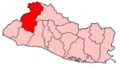
Coordinates: 14°11′N 89°26′W / 14.183°N 89.433°W
Categories:- Populated places in El Salvador
- Municipalities of the Santa Ana Department
- El Salvador geography stubs
Wikimedia Foundation. 2010.