- Meanguera del Golfo
-
For a town in Morazán Department, see Meanguera, Morazán.
Meanguera del Golfo — Municipality — 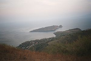 Location in El Salvador
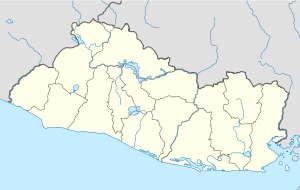
 Meanguera del Golfo
Coordinates: 13°10′47″N 87°41′51″W / 13.17972°N 87.6975°WCoordinates: 13°10′47″N 87°41′51″W / 13.17972°N 87.6975°W Country  El Salvador
Department La Unión Department Area - Total 9.1 sq mi (23.6 km2) Population (2007) - Total 2,398
Meanguera del Golfo is a municipality in the La Unión department of El Salvador. Located 30 km from department of La Unión and 213 km from San Salvador on the island of Meanguera in the Gulf of Fonseca. It has an area of 23.6km² with a population of 2,398 inhabitants (2007).Three countries - Honduras, El Salvador, and Nicaragua - have coastline along the gulf, and all three have been involved in a lengthly dispute over the rights to the gulf and the islands located there within. In 1992, a chamber of the International Court of Justice (ICJ) decided the Land, Island and Maritime Frontier Dispute, of which the gulf dispute was a part. The ICJ determined that El Salvador, Honduras, and Nicaragua were to share control of the Gulf of Fonseca. El Salvador was awarded the islands of Meanguera and Meanguerita, and Honduras was awarded El Tigre Island.
External links
Capital: La UniónMunicipalities · Anamorós · Bolívar · Concepción de Oriente · Conchagua · El Carmen · El Sauce · Intipucá · La Unión · Lislique · Meanguera del Golfo · Nueva Esparta · Pasaquina · Polorós · San Alejo · San José · Santa Rosa de Lima · Yayantique · Yucuaiquín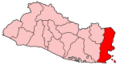 Categories:
- Islands of El Salvador
- Territorial disputes of Honduras
- Territorial disputes of El Salvador
- El Salvador–Honduras border
- Populated places in El Salvador
- Municipalities of the La Unión Department
- El Salvador geography stubs


Wikimedia Foundation. 2010.