Koblenz-Arzheim

Koblenz-Arzheim
Koblenz-Arzheim
Location of Arzheim within Koblenz
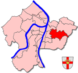
Basic Information
Suburb since: 1970
Area: 4,87 km²
Population: 2.217 (11.2006)
Population Density: 450 Inhabitants per km²
Post Code: 56077
Area Code: 0261
License Plate: KO
Suburb
Mayor: Josef Krämer

Since 1970 the village Arzheim has been incorporated into the jurisdiction of the city of Koblenz. Hence, the village of Arzheim is now being referred to as Koblenz-Arzheim. 2.200 people live in this suburb, in an area of 4,87km2.

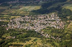
Aerial photograph 2007

History

Historical documents are proof, that the first mentioning of Arzheim has been in 868 A.D. However, excavations show that settlement in this area dates back to some time in B.C.

Village Live

Arzheim is well-known in the surroundings of Koblenz for its many festivals where the whole community gathers. Most famous is the annual Kirmes (a type of fun fair involving drinking and dancing) in August and the Carnival in February.

Coordinates: 50°21′18″N 7°37′57″E / 50.355°N 7.6325°E / 50.355; 7.6325


Wikimedia Foundation. 2010.

Игры ⚽ Поможем решить контрольную работу

Look at other dictionaries:

  • Koblenz-Arzheim — Basisdaten Stadtteil seit: 1970 Fläche: 4,87 km² …   Deutsch Wikipedia

  • Liste der Kulturdenkmäler in Koblenz-Arzheim — In der Liste der Kulturdenkmäler in Koblenz Arzheim sind alle Kulturdenkmäler im Stadtteil Koblenz Arzheim der rheinland pfälzischen Stadt Koblenz aufgeführt. Grundlage ist die Denkmalliste des Landes Rheinland Pfalz (Stand: 2. Februar 2010).… …   Deutsch Wikipedia

  • Arzheim — steht für: Koblenz Arzheim, Stadtteil von Koblenz Landau Arzheim, Stadtteil von Landau in der Pfalz Diese Seite ist eine Begriffsklärung zur Unterscheidung mehrerer mit demselben Wort bezeichneter Begriffe …   Deutsch Wikipedia

  • Koblenz (am Rhein) — Wappen Deutschlandkarte …   Deutsch Wikipedia

  • Koblenz-Immendorf — Basisdaten Stadtteil seit: 1970 Fläche: 2,53 km² …   Deutsch Wikipedia

  • Koblenz-Ehrenbreitstein — Basisdaten Stadtteil seit: 1937 Fläche: 1,61 …   Deutsch Wikipedia

  • Koblenz-Asterstein — Basisdaten Stadtteil seit: Gründung 1981 Fläche:  ? …   Deutsch Wikipedia

  • Koblenz-Lützel — Basisdaten Stadtteil seit: 1891 Fläche:  ? km² …   Deutsch Wikipedia

  • Koblenz-Horchheim — Basisdaten Stadtteil seit: 1937 Fläche: 7,7 km² …   Deutsch Wikipedia

  • Koblenz-Metternich — Basisdaten Stadtteil seit: 1937 Fläche: 4,8 …   Deutsch Wikipedia

Share the article and excerpts

Direct link
Do a right-click on the link above
and select “Copy Link”