- Texas State Highway 4
Infobox TX State Highway
type=State
route=4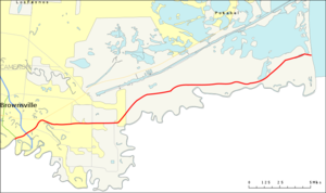
length_mi=24.4
length_ref=TxDOT|SH|4|accessdate=2008-03-15]
length_round=1
formed=before 1939
dir1=West
dir2=East
from=MX 180 inMatamoros ,Tamaulipas ,Mexico
junction=jct|state=TX|US|77|US|83 in Brownsville
jct|state=TX|TX|48 in Brownsville
to=Boca Chica State Park
previous_type=State
previous_route=3
next_type=State
next_route=5|State Highway 4 or SH 4 is an east-west state highway that runs from the Gateway International Bridge in Brownsville to the
Gulf of Mexico atBoca Chica State Park . Outside of Brownsville, it parallels theRio Grande river. It is the southernmost Texas state highway.History
SH 4 was one of the original twenty six state highways proposed in
1917 , overlayed on top of theDel Rio - Canadian Highway . From1919 the routing mostly followed present day U.S. Highway 83 from Perryton, Childress, to Aspermont. From here, it followed present day FM 610 and SH 70 to Blackwell. It then continued down U.S. Highway 277 into Sweetwater,San Angelo and Sonora. From here, it split into two routes. The western branch terminated inDel Rio and the eastern terminated at Uvalde. The road at this time also had numerous alternate routes simultaneously marked as SH 4, along with occasionally signed SH 4A routes (although most of those routes were given their own numbers by the 1930s).In
1926 , U.S. Highway 83 was routed over SH 4 fromOklahoma to Del Rio. The road was then extended toBrownsville , taking over the proposed Del Rio/Laredo segment of the now severely reworked SH 12. The eastern branch from Sonora to Del Rio was then given the designation State Highway 55. Both SH 4 and US 83 were marked concurrently at the time. Unable to create the proposed road, by1932 , a new route was under construction south east from Aspermont, taking SH 4 through Abilene, Junction, Uvalde,Carrizo Springs and finally, Laredo.Route Description
SH 4 begins at the
Gateway International Bridge in downtown Brownsville, travelling northeast on International Blvd. A mile later, it reaches the US 77/83 expressway. This first one mile section was previously the final stretch of US 77 and 83 before they were rerouted to the southeast around downtown to theVeteran's International Bridge . SH 4 continues northeast, passing the intersection with Farm to Market Road 1418, until it reaches an intersection with SH 48 at Boca Chica Blvd. SH 4 turns east onto Boca Chica Blvd. About a mile to the east is the cutoff for Farm to Market Road 2519, which leads to theBrownsville/South Padre Island International Airport . SH 4 continues east, passing along the north side of the airport grounds and meeting intersections with Farm to Market Roads 313 and 511. SH 4 exits Brownsville continuing east near the southern side of the Port of Brownsville. This section passes a few historical landmarks, including the site of theBattle of Palmito Ranch , site of the final battle of the AmericanCivil War . The highway continues east-northeast until it reaches a stop sign at Boca Chica Beach and Brazos Island State Park.Junction List
References

Wikimedia Foundation. 2010.