- Xanthi Prefecture
Infobox Pref GR
name = Xanthi
name_local = Νομός Ξάνθης
flag_reg =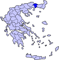
periph =East Macedonia and Thrace
capital =Xanthi
population = 105,530
population_as_of = 2005
pop_rank = 36th
pop_dens = 58.9
popdens_rank = 22nd
area = 1,793
area_rank = 37th
postal_code = 67x xx
area_code = 254x0, 25540
licence = ΑΗ
provinces =
municip = 6
commun = 4
ISO = GR-72
website = [http://www.xanthi.gr www.xanthi.gr]Xanthi ( _el. Ξάνθη, "Xánthi", IPA2|ˈksanθi) is one of the
prefectures of Greece . It is within theEast Macedonia and Thrace periphery. Xanthi has no or only one province. The capital of the prefecture is also calledXanthi . Xanthi is the smallest prefecture in area and population in all of Thrace and is the westernmost.Xanthi borders
Bulgaria along theRhodope Mountains to the north, and theAegean Sea to the south. The prefecture of Kavala lies to the west, Drama to the northwest and Rhodope to the east. The mountains ofKoula lie to the east and thePapingio to the northeast.Of special interest in the Xanthi prefecture are the Byzantine castle around the old town of Xanthi and the subterranean Macedonian tombs in Komnina from the
2nd century BC . During the 19th century, local tobacco production and commerce developed rapidly. The manors of the old city, many of which are still intact, testify to the prosperity of the tobacco merchants of Xanthi during this period.Climate
The areas that mainly get Mediterranean climate is at the southern and the central portion. Its climate is mainly continental with cold winters in higher elevations and the northern part.
Transport
*GR-2/
E90 ,Via Egnatia , old and new, SW, Cen., S, SE
*GR-12/E90, W, Cen.
*GR-55Archaeological sites
Municipalities and communities
ee also
*
List of settlements in the Xanthi prefecture
*Slavic toponyms of places in Xanthi Prefecture
Wikimedia Foundation. 2010.