- Central Link
Infobox rail line
name = Central Link
image_width = 300px
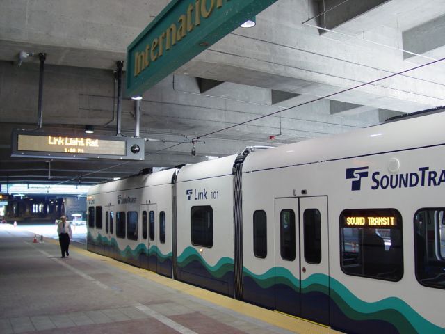
caption = The first trains on a test run in the tunnel.
type =Light rail
system =Link Light Rail
status = Under construction
start = Sea-Tac Airport
end =Westlake Center
stations = 4 (10 under construction)
open = July 2009
close =
owner =Sound Transit
operator =Sound Transit
character = Underground, at grade, elevated
stock =
linelength = mi to km|15.7|abbr=yes
tracklength =
notrack = 2
gauge = RailGauge|ussg
el =Overhead catenary
speed = Auto mph|55
infobox rdt|Central Link map
map_state = collapsed|Central Link is a 15.7-mile (25.3 km)
light rail line running between downtownSeattle andSeattle-Tacoma International Airport inSeaTac, Washington . It is currently under construction, and represents the initial phase of theSound Transit agency'sLink Light Rail system. The line will begin service in Summer 2009.Routing
The southern terminus of Central Link at Sea-Tac Airport will be an elevated station lying north of the parking garage. The garage's return-to-terminal ramps have been demolished to make way for the light rail station.
The route travels north on a grade separated viaduct/bridge along the North Airport Expressway, crosses over State Route 518, travelling on the north side of the highway. It then runs alongside Interstate 5, SR 599, Interurban Blvd., and Boeing Access Rd..
Entering Seattle proper, the line becomes an at-grade surface route on Martin Luther King Jr. Way S through the Rainier Valley. When it nears Franklin High School the route again becomes grade separated, rising on an elevated bridge before entering a tunnel through Beacon Hill, leading to another elevated section through the SoDo district. The route then joins the E-6 Busway (formerly 5th Avenue S) as a grade separated surface route.
Central Link trains will then enter the Downtown Seattle Transit Tunnel, sharing the right-of-way with diesel-electric hybrid buses. The route ends at Westlake Station near the intersection of Pine Street and 5th Avenue.
Future plans for Central Link call for extending the route north from Westlake Center in a tunnel to the
University of Washington , and then to Northgate, and eventually to Lynwood and Everett. In the south it would be extended to S. 200th Street, approximately 3,000 meters beyond the airport station, and eventually to Federal Way andTacoma .tations
Name Opening Year City/Neighborhood Location Other Central Link (Airport-Downtown Seattle) Elevated Sea-Tac Airport 2009 Seatac North of parking garage pedestrian bridges to main terminal & kiss-and-ride center at Int'l Blvd Tukwila Int'l Blvd 2009 Tukwila SR 518 & Int'l Blvd 600-space park & ride lot; free shuttles to/from the airport until Airport section is complete Boeing Access Road N/A Tukwila I-5 & Boeing Access Rd station deferred indefinitely Surface (Martin Luther King Jr. Way) Rainier Beach 2009 Rainier Valley, Seattle MLK Jr. Way & S Henderson St Othello 2009 New Holly, Seattle MLK Jr. Way between
S Othello St & S Myrtle StColumbia City 2009 Columbia City, Seattle MLK Jr. Way between
S Edmunds St & S Alaska StElevated Mount Baker 2009 Mount Baker, Seattle MLK Jr. Way & Rainier Ave Tunnel Beacon Hill 2009 Beacon Hill, Seattle Underground station at
Beacon Ave S & S Lander StSurface SODO 2009 SoDo, Seattle SODO Busway & S Lander St Stadium 2009 SoDo, Seattle SODO Busway &
S Royal Brougham Waylarger platform to serve Safeco Field and Qwest Field Downtown Seattle Transit Tunnel 1989 International District
/ Chinatown, Seattleunder Union Station 1989 Pioneer Square, Seattle under 3rd Ave & Cherry St 1989 Downtown Seattle under 3rd Ave & University St 1989 Downtown Seattle under Pine St & 4th Ave connections to monorail and streetcar. End of line; future extension ( University Link )Equipment
Kinkisharyo-Mitsui was chosen to design and manufacture low-floor light rail vehicles and provide additional equipment and support. Thirty-five Electric Multiple Units are to be delivered between November2006 and September2008 . As of June2008 , twenty-five of these vehicles are at the facility and many are testing in Seattle, with additional vehicles in final assembly in Everett. Each vehicle is 95 feet (30 m) long, accommodate 200 people each (74 seated), and double-ended to allow travel in either direction. Two-car trains will be used initially, but as ridership increases, can run up to four-cars long. The maximum speed of the light rail vehicle is 65 mph (105 km/h). Sound Transit will operate these vehicles at a maximum and cruising speed of 55 mph (89 km/h), with an estimated end-to-end travel time of 30 minutes over the 15.7 mile route.cite web | title = Link Light Rail Train Specifications | publisher =Sound Transit | url = http://www.soundtransit.org/x4306.xml | accessdate = 2008-03-18] cite web | title = Link Light Rail Fact Sheet | publisher =Sound Transit | date = December 2007 | url = http://www.soundtransit.org/documents/pdf/projects/link/FACT_Link.pdf | format = pdf | accessdate = 2008-03-18]ee also
*
Tacoma Link
*University Link
*List of rapid transit systems References
External links
* [http://www.soundtransit.org www.soundtransit.org]
* [http://www.sireneinternet.net/pstran/sealink Puget Sound Transportation Projects: Seattle Link]
* [http://www.soundtransit.org/images/projects/lightrail/MAP_Central-Link.jpgSystem Map(Project) by Sound Transit]
* [http://flickr.com/groups/soundtransit/ Photos of Sound Transit]
Wikimedia Foundation. 2010.