- Dirleton railway station
-
Dirleton 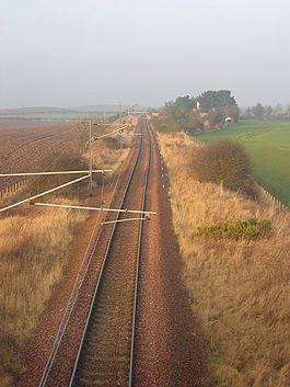
The building in the trees was once Dirleton Station. Location Place North Berwick Area East Lothian Coordinates 56°02′06″N 2°45′33″W / 56.03489°N 2.75905°WCoordinates: 56°02′06″N 2°45′33″W / 56.03489°N 2.75905°W Operations Original company North British Railway Post-grouping LNER Platforms 1 History 17 June 1850 Opened 1 February 1954 Closed Disused railway stations in the United Kingdom Closed railway stations in Britain
A B C D–F G H–J K–L M–O P–R S T–V W–ZDirleton railway station was a railway station on the North Berwick Branch of the North British Railway in East Lothian, Scotland. It was an intermediate station on the branch line from Drem.
History
Dirleton station was a small affair, with a single platform and two sidings on the south side of the line. There was no signalbox, and the siding points were controlled by a ground frame.
Dirleton station closed to passengers on 1 February 1954, with the goods yard surviving as an unstaffed public siding until 1 June 1959. The station house is now privately owned, and the station site is clearly visible from passing trains.
Although named for the village of Dirleton, the station was actually some distance away, approximately half way between Dirleton and Kingston. A plan to give Direlton a more convenient station was put forward by the Aberlady, Gullane and North Berwick Railway, which was founded in 1893. This company opened its line from Spittal (Aberlady Junction) near Longniddry to Gullane in 1898, but plans to extend it to join the North Berwick branch near Williamstown were never implemented.
Previous services
Preceding station Historical railways Following station Williamstown
Line open; Station closedNorth British Railway
Drem
Line and Station openSources
- Butt, R. V. J. (1995). The Directory of Railway Stations: details every public and private passenger station, halt, platform and stopping place, past and present (1st ed.). Sparkford: Patrick Stephens Ltd. ISBN 1-8526-0508-1. OCLC 60251199.
- Hajducki, Andrew M. (1992) The North Berwick and Gullane Branch Lines, Headington, Oakwood Press, ISBN 085361427X
- Jowett, Alan (March 1989). Jowett's Railway Atlas of Great Britain and Ireland: From Pre-Grouping to the Present Day (1st ed.). Sparkford: Patrick Stephens Ltd. ISBN 1-8526-0086-1. OCLC 22311137.
- RAILSCOT on the North Berwick Branch
Categories:- Railway stations opened in 1850
- Railway stations closed in 1954
- Disused railway stations in East Lothian
- Railway stations served by First ScotRail
- Scotland railway station stubs

Wikimedia Foundation. 2010.