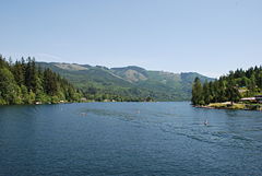
- Lake Samish
-
Lake Samish 
Location Whatcom County, Washington Coordinates 48°40′N 122°23′W / 48.667°N 122.383°WCoordinates: 48°40′N 122°23′W / 48.667°N 122.383°W Primary outflows Friday Creek[1] Basin countries United States Surface elevation 276 ft (84 m) Not to be confused with Lake Sammamish.Lake Samish is a lake south of Bellingham, Washington.
Visible to the West of Interstate 5 when travelling between Alger and Bellingham, Lake Samish is heavily used for recreation in the summer months by local residents. The lake shoreline is heavily developed and homesites cover almost the entire shoreline. Lake Samish is bordered on the south by Blanchard Mountain and on the north by Chuckanut Pass. Public access is limited but a Whatcom County park with a rough boat launch is located along the northern shore.
In pre-Colonial days, members of the Samish tribe lived at sites on the lake. It is often confused with Sammamish.
The Northwestern Shore of Samish is home to Lutherwood Camp and Retreat Center which has sat on the lake since 1946, and is a large player in the Samish community.
There are hiking trails, picnic tables, BBQ pits, and restrooms. On weekends the staff is present and keeps the table, the area, and the restrooms clean. Boat rentals (human powered) start June 1.
The first European to discover lake Samish was a man named William Harris who discovered it in 1870 and later picked out an 160-acre (0.65 km2) plot of land, built a cabin there and lived out the remainder of his days in it.
References
- ^ Arthur G. Larson (October 1988). "Domestic Water Withdrawals From Lake Samish". Water Resources Publications. Washington State Department of Ecology. http://www.ecy.wa.gov/pubs/oftr8802.pdf. Retrieved 12 June 2011.
External links
- http://www.co.whatcom.wa.us/parks/samish/samish.jsp (Samish Park)
- http://www.lakesamish.org (Lake Samish Association)
- http://www.lakesamish.com Webcam
- http://www.camplutherwood.org Lutherwood Camp and Retreat Center
- http://www.aacb.com/cams/lakecam.htm Webcam
- http://www.lakesamishtriathlon.com/ Lake Samish Triathlon
- U.S. Geological Survey Geographic Names Information System: Lake Samish
Categories:- Landforms of Whatcom County, Washington
- Lakes of Washington (state)
- Washington (state) geography stubs
Wikimedia Foundation. 2010.
